Note: The FAQ has not been revised since 2007. Much of the information is also available at Wikipedia, which has a road section, and may be more up-to-date. The AARoads website also has a wiki. Any inquiries may be submitted via e-mail (see Question 100 at bottom).
September 26, 2012 / June 27, 2026
If you are having trouble finding a subject in the table of contents below, a text search of this document may be helpful. If reading this on the World Wide Web, choose Edit: Find or other similar command from the toolbar in your browser.
Note: Map references are now given in latitude and longitude, due to most online mapping services easily incorporating the data. Use one of the following URLs to get a map (* = latitude and ** = longitude, the latter of which will be a negative number [west] for nearly all of North America):
1.1 What is misc.transport.road?
1.1.1 What types of postings are acceptable on misc.transport.road?
1.1.2 Why are people talking about (insert offtopic subject) on m.t.r?
1.2 Is there a roadgeek mailing list?
1.3 What other newsgroups are similar to misc.transport.road?
3.1 Breezewood
3.2 Business Routes
3.3 Button Copy
3.4 Control City
3.4.1 What are the longest distances listed to a particular control city?
3.4.2 Which control city for an Interstate has the smallest population?
3.5 Decommission
3.6 Interchanges
3.6.1 SPUI
3.6.2 What is the longest distance between interchanges?
3.6.3 Exit Lists
3.6.4 Interchange names
3.6.5 Volleyball
3.6.6 One-quadrant ramp
3.6.7 Truck escape ramps
3.7 Jersey Barrier
3.8 Mileposts
3.9 Multiplex
3.9.1 What is the highway with the most multiplexes?
3.10 Ramp to Nowhere
3.11 Roadgeek
3.12 Super 2
3.13 Toll highway
3.13.1 E-ZPass
3.14 What is the difference between an expressway and a freeway? What is the difference between limited access and controlled access?
3.14.1 What is the difference between the terms "highway" and "route" when referring to numbering systems?
3.15 Spur
3.16 What is the difference between a traffic circle and a roundabout?
3.16.1 Where is the Magic Roundabout?
3.17 Bump
3.18 Cutout
3.19 Clinch
4.1 What is FHWA?
4.2 What is AASHTO?
4.3 What are ISTEA, TEA-21, and SAFETEA-LU?
4.4 What are the Appalachian Regional Corridors?
6.1 Interstate History
6.1.1 How did the Interstate Highway System come to be?
6.1.2 What was the first stretch of Interstate to open?
6.1.3 What were the early plans for Interstates?
6.2 Interstate Numbering
6.2.1 Letter Suffixes
6.2.1.1 What happened to letter extensions on Interstate highways?
6.2.1.2 Why does I-35 split in Dallas and Minneapolis?
6.2.1.3 What are/were all the suffixed interstates?
6.2.2 Why the heck does I-99 have such a weird number?
6.2.3 What is I-238?
6.2.4 Why are there two Interstates 76, 84, 86 and 88?
6.2.5 Which 3di spurs go both directions from a parent?
6.3 Oddities
6.3.1 What happens to I-95 in NJ?
6.3.1.1 Are I-95's exit numbers between I-80 and NY an extension of I-80's?
6.3.2 Why do some Interstates, such as I-180 in WY, have traffic lights or at-grade intersections?
6.3.3 Where was the Embarcadero Freeway and why was it torn down?
6.3.4 Why are these I-73 and I-74 signs popping up in North Carolina?
6.3.5 Why are there freeway loops in Phoenix?
6.3.6 What is the new I-86?
6.3.6.1 Does it really dip into Pennsylvania?
6.3.7 Where are all the drawbridges on the Interstate system?
6.3.8 Why are there Interstate highways in Hawaii? Are there plans for Interstates in Alaska or Puerto Rico? Are there any freeways in Alaska or Puerto Rico?
6.3.9 What's up with I-585 in Spartanburg, SC?
6.3.10 Why is the Chicago Skyway no longer I-90?
6.3.11 Why does I-180 in IL exist?
6.3.12 What happened to I-265 in Nashville?
6.3.13 Are Kentucky's parkways built to Interstate standards?
6.3.14 Why do I-17's exit numbers start so high?
6.3.15 What's with the I-465 spur northwest of Indianapolis? What is it designated?
6.3.16 Has there been a proposal to extend eastern I-76 eastward?
6.3.17 What's with I-22?
6.3.18 What's with I-41?
6.3.19 What's with the proposed Interstates in in the southern US?
6.4 Why do people want I-69 extended?
6.5 What's this I hear about a new Interstate marker?
6.6 Is one mile of each five in the Interstate system required to be able to act as an emergency landing strip for aircraft?
6.7 What is PrePass?
6.8 What is the largest city without an Interstate?
6.9 Interstate Standards
6.10 Where is the longest stretch between services on an Interstate?
6.10.1 Where is the longest stretch between other Interstates on an Interstate?
6.11 Tunnels
6.12 Intrastate Interstates
6.13 Multistate 3di's
6.14 Which 3dis exist in states where their parents are not?
6.15 What are the highest and lowest elevations on the Interstate system?
6.16 Which Interstate and US route pair crosses each other the most?
6.17 Do Interstates have publicly-accessible U-turn ramps in places?
6.18 What's with crossing gates on onramps?
7.1 Is the US route system a federal program?
7.1.1 Do Federal funds support the US system?
7.2 US Highway Numbering
7.2.1 Why are there still US routes with directional suffixes and single state US routes?
7.3 How old is the US route system?
7.4 Why has so much of the US highway system been decommisioned?
7.4.1 What happened to US 66?
7.4.1.1 What happened to US 666?
7.4.2 What happened to US 99?
7.5 What's with the new US routes?
7.6 Miscellaneous
7.6.1 What is the longest US route?
7.6.2 What is the shortest US route?
7.6.3 What are the current remaining single-state US routes?
7.6.4 Why do US routes in the southeast have concurrent state routes?
7.6.5 Where is the north end of US 25?
7.7 What is the National Highway System?
7.8 What happened to the colored US routes?
7.9 Which Interstate and US route pair crosses each other the most?
7.10 Are there any more unpaved sections of US routes?
8.1 How come so many routes keep numbers when crossing state boundaries?
8.2 What is the shortest numbered highway?
8.3 What is the highest numbered highway?
8.3.1 What is the most common street name in the US?
8.4 Why is WY 789 numbered as such?
8.5 Why is FL A1A numbered (and lettered) as such?
8.6 Why do many state routes in New England keep their numbers between states?
8.7 What's with the WV fractional routes?
9.1 Which countries use right-side driving, and which use left-side driving?
9.2 Canada
9.2.1 What is the Trans-Canada Highway?
9.2.2 What is the Quebec Autoroute system?
9.3 Mexico
9.4 Europe
9.4.1 France
9.4.2 United Kingdom
9.5 Australia
10.1 What does the highway marker look like in...?
10.1.1 Are route markers painted on pavement anywhere?
10.2 What are the fonts used in signage?
10.3 How do exits get their numbers?
10.3.1 Where are there fractional milemarkers?
10.3.2 What is the highest number or distance on a milemarker?
10.3.3 Where is there an Exit 0?
10.3.4 What is the highest-lettered exit?
10.4 What's with the new fluorescent color for signs?
10.5 Where can one buy road signs?
10.6 Speed limits
10.7 Sign art
10.8 What's with the services signs with business logos?
10.9 What's with the permanent detour signs in PA and MI?
10.10 What does "HM" mean?
10.11 Trucker jargon
11.1 What does a blinking green light mean?
11.1.1 What does a blinking yellow arrow mean?
11.1.2 What does a blinking walk signal mean?
11.2 What does it mean when the red and yellow lights are on at the same time?
11.3 Why do some red lights have strobe lights? Are these a danger to people with epilepsy?
11.4 What do the signals look like in...?
11.5 What are LED signals?
11.6 What are countdown crosswalk signals?
11.7 Are there audible crosswalk signals?
11.8 Where is that upside-down signal?
11.9 Is there a traffic signal sculpture?
11.10 Where are there horizontal traffic signals?
11.11 Ramp meters
11.12 Why can't I see the signal indication?
11.13 Who invented the traffic light?
11.14 What is the difference between permissive and protected left turns?
12.1 Where is there left-hand drive in right-hand drive countries?
12.2 Which highways either just enter or just miss a state?
12.3 Which freeways have the most lanes at one point (not counting toll booths or ramps)?
12.4 What songs are about roads?
12.4.1 What movies and television shows contain many road scenes?
12.4.2 Board games
12.5 What were auto trails?
12.6 What is the greatest distance between roadways of a divided highway?
12.7 What was that old bridge that shook itself apart?
12.8 What is a suicide lane?
12.8.1 Reversible lanes
12.9 What is a zipper lane?
12.10 Pavement markings
12.11 What and where are floating bridges?
12.12 What is the name of the area between a road and an adjacent sidewalk?
12.13 Where is the longest 6-lane stretch?
12.14 Do highways loop around themselves?
12.15 Are there any rest areas in the medians of divided highways?
12.16 Which routes have direction indication changes?
12.16.1 Which routes have significant portions 180 degrees from their direction indications?
12.17 Have there been posted directions other than cardinal (N/S/E/W)?
12.18 Double-deck streets
12.19 Road designators
12.20 Sports venues
13.1 Where can I go to find out where road construction is in a certain area?
14.1 Where can I find old maps?
14.1.1 Why are many route numbers in the 1926 Rand McNally U.S. atlas wrong?
14.2 Where can I find current maps?
14.3 Why do different computer mapping programs have the same mistakes?
15.1 Are Wisconsin's and Missouri's lettered routes county highways?
16.1 What are some road-related jobs?
16.2 What should I study in school?
16.2.1 Schools
16.3 Job resources
17.1 Historical Archives
19.1 What are the best cameras for taking road photos?
19.2 Where are there road photos on the Internet?
What is misc.transport.road?
misc.transport.road is an unmoderated (uncensored, uneditable) Usenet newsgroup in which individuals may discuss issues pertaining to road transportation and design. Read misc.transport.road using Google Groups Usenet archive: http://groups.google.com/group/misc.transport.road . Usenet is described at http://www.faqs.org/usenet/ , http://en.wikipedia.org/wiki/Usenet , http://www.smr-usenet.com/tech/about.shtml , and http://www.columbia.edu/~hauben/netbook/ (1997). Sep 13, 2005
Q: What types of postings are acceptable on misc.transport.road?
A: The charter is as follows:
The charter is archived at http://faqs.org/usenet/news.announce.newgroups/misc/misc.transport.misc .
m.t.r is not for only US-related topics, although it is dominated by them.Binary files are not appropriate on m.t.r .
Sep 28, 2004
Q: Why are people talking about (insert offtopic subject) on m.t.r?
A:
Radio/TV stations | Gas stations/restaurants/stores | License plates | Geographical names | Government units | Area codes | ZIP codes | Time Zones
Radio/TV stations: This started because of people talking about it in roadtrip reports; it usually starts as an on-topic thread and drifts off-topic. Go to http://www.fcc.gov/fcc-bin/audio/tvq.html for a list of American TV stations (this also accesses radio station information). See also http://dmoz.org/Arts/Radio/Resources/Guides/ , http://dmoz.org/Arts/Radio/Internet/Directories/ , and http://dmoz.org/Arts/Television/Stations/
Gas stations/restaurants/stores: Gas stations came first as offshoots of roadtrip reports, generally to mention prices of fuel; now new threads have been started about current and former restaurant and store chains. A site with links to nearly all active U.S. retail chains is located at http://www.synergos-tech.com/crossroads/business.htm . More information may be found at http://dmoz.org/Business/Retail_Trade/ . Information about old supermarket chains may be found at http://www.groceteria.net/ . Malls and other retail outlets no longer extant or with few locations remaining are discussed at http://www.deadmalls.com/ . A timeline of significant events in retail in the 20th Century is at http://retailtrafficmag.com/ar/retail_cheers_years_th/ . Stuckey's information is at http://www.stuckeys.com/ , http://www.stuckonstuckeys.com/ , and http://www.wunderland.com/WTS/Rash/stuckey.html . Gas prices may be located at http://www.gaspricewatch.com/ , http://www.gasbuddy.com/ , or various sites at http://dmoz.org/Home/Consumer_Information/Automobiles/Fuels/Price_Comparisons/ . Gas station memorabilia is the subject of http://www.oldgas.com/ . A discussion group about oil company history is at http://groups.yahoo.com/group/oilhistory/ .
License plates: Obviously license plates are visible anytime one uses a road. For a directory of webpages showing photos of current standard, current special, and old license plates, go to http://dmoz.org/Recreation/Collecting/Themes/Transportation/Automobiles/License_Plates/ .
Geographical names: These names arise when posters discuss the ownership of a certain road or the style of boundary signs. One may use http://geonames.usgs.gov/pls/gnis/web_query.gnis_web_query_form to find all geographic names in the United States, and http://geonames.nrcan.gc.ca/search/search_e.php for all names in Canada. http://www.wordways.com/commonp.htm lists the number of occurences of certain place names in the U.S. ("Midway" occurs 211 times as-is and 250 times with slight variations, while "Fairview", occurs only 201 times as-is but 256 times with slight variations; the name which occurs in the most states is "Riverside", only absent from AK, HI, LA, and OK). A compilation map with names created by two or more U.S. states due to the position near those states is located at http://www.geocities.com/mapguygk07/Misc/Statelines/ (see also http://en.wikipedia.org/wiki/Category:Geographic_portmanteaus ).
A listing of the most frequently misspelled U.S. city names is at http://www.epodunk.com/top10/misspelled/ , which includes Cincinnati.
A partial listing of names of towns with the same names as nearby towns in adjacent US states is at http://www.zifyoip.com/stuff/citypairs.txt .
Government units: These come up due to the same reasons as geographical names. Posters from areas without certain units become confused over their meanings when they are mentioned. The United States Bureau of the Census assigns two main types of unit below the county-level: Municipalities and townships.
Municipalities are governments that are traditionally based around a single concentration of population. "City" is the common name for a large municipality; smaller ones include "village," "town," and "borough," though places labelled by those names might not actually be incorporated. Most municipalities have an elected council and sometimes a mayor.
Townships are direct divisions of counties. They exist only in the Northeast and Midwest U.S., and are generally unincorporated except in New Jersey. (There are also land survey divisions called "townships", but these are not usually the type being discussed -- see http://www.ca.blm.gov/pa/cadastral/meridian.html for a map of areas which use this type.) "Town" in this context refers to the same type of entity, just with a different name, used in New England, New York State, and Wisconsin, though towns in New England are incorporated, are similar to cities, and often are more powerful than townships are. This "town" is not to be confused with the more general meaning of "town" above. Townships/towns are usually governed by an elected board of "supervisors," "trustees" or "selectmen," which in New England are sometimes supplemented with town meetings. See also the Census Bureau's Geographic Areas Reference Manual, Chapter 8 ( http://www.census.gov/geo/www/garm.html ), and http://en.wikipedia.org/wiki/Civil_township
A special circumstance is home rule, defined as "self-government or limited autonomy in internal affairs by a dependent political unit (as a territory or municipality)" (Merriam-Webster), which usually comes up when discussing routes in a state system which otherwise would be fully state-maintained. A home rule reference is Home Rule in America: A Fifty-State Handbook by Krane/Rigos/Hill, ISBN 1568022816 ( http://www.cqpress.com/product/Home-Rule-in-America-A-Fifty-State.html , abridged table at http://www.cla.sc.edu/poli/civiced/Reference%20Materials/US_home_rule.htm ).
A special type of municipality is the independent city. These are cities separate from any county. In the United States, the independent cities are Baltimore; St. Louis; Carson City, NV; and all cities in VA ( http://www.vipnet.org/cmsportal/localgov_old.htm#city ). Washington is wholly within the District of Columbia and therefore separate from all states as well as counties (DC has had no counties for a long time).
Counties have "collectors", those who make a roster of ones visited. Many roadgeeks travel as many roads as they do because they are county collectors. See http://www.extramilerclub.org/ , http://www.countycounters.com/ , and http://www.mob-rule.com/counties/ .
For more information, see http://groups.google.com/group/misc.transport.road/browse_frm/thread/4f046af1cfe0f7eb , especially message 16 ( http://groups.google.com/group/misc.transport.road/msg/266bc5b127d59585 , message ID 0014749c.4288b434@usw-ex0104-033.remarq.com ) , the Census Bureau website at http://www.census.gov/ , and Rand McNally's Commercial Atlas and Marketing Guide, available at most larger libraries or at http://www.randmcnally.com/rmc/promo/promoCAO.jsp .
A list of each state's smallest municipality per the 2000 U.S. Census is located at http://groups.google.com/group/misc.transport.road/msg/b6237468990d6bbc (12/6/05 - Message ID: 1133924285.930983.52500@z14g2000cwz.googlegroups.com ).
Area codes: Usually a secondary off-shoot of the above. Thorough area code information is at http://www.lincmad.com/ and http://www.nanpa.com/ . See also http://dmoz.org/Reference/Directories/Address_and_Phone_Numbers/Area_Codes/ and http://dmoz.org/Business/Telecommunications/Resources/Numbering/ .
ZIP codes: Similar to area code discussion. ZIP codes are American postal codes, 5 digits long with an optional 4-digit suffix ("ZIP" stands for "Zone Improvement Plan"). http://zip4.usps.com/zip4/ is the United States Postal Service page which includes an FAQ and a locator; http://acg.media.mit.edu/people/fry/zipdecode/ is an unofficial map locator.
Canadian postal codes are covered at http://www.canadapost.ca/tools/pcl/bin/advanced-e.asp .
Time zones: These are usually mentioned in reference to signs designating them or to old maps which show former boundary alignments. http://www.worldtimezone.com/ shows boundaries worldwide; http://www.time.gov/ has US boundaries as well as links to pages on time zone history (official zone and boundary definitions are at http://www.access.gpo.gov/nara/cfr/waisidx_03/49cfr71_03.html ). Standardized daylight-saving time in the US was created by the Uniform Time Act of 1966 http://tycho.usno.navy.mil/260.html ; states observing year-round standard time (AZ, HI, formerly IN, possibly future ME) are documented at http://www.mccsc.edu/time.html . A history of daylight-saving time is at http://webexhibits.org/daylightsaving/ . See also http://en.wikipedia.org/wiki/Time_zone and http://en.wikipedia.org/wiki/Daylight_saving_time
Making repeated off-topic posts in any newsgroup is generally considered bad Netiquette ( http://faqs.org/usenet/ ; http://en.wikipedia.org/wiki/Netiquette ).
Apr 5, 2007
Q: Is there a roadgeek mailing list?
A: There are many. See http://www.aaroads.com/kick-off/highway.html#lists and http://dmoz.org/Recreation/Roads_and_Highways/Mailing_Lists/ .
Jul 13, 2004
Q: What other newsgroups are similar to misc.transport.road?
A: Here are some related newsgroups:
misc.transport.trucking
misc.transport.urban-transit
alt.planning.urban
sci.engr.civil
sci.geo.* newsgroups, especially sci.geo.satellite-nav and sci.geo.cartography
alt.petromatica (Gasoline)
rec.autos.driving
alt.travel.road-trip
Various rec.travel.* newsgroups
Various regional transportation newsgroups including dc.driving, phl.transportation, nyc.transit ,ne.transportation, la.transportation, and ba.transportation
Jul 19, 2005
2 Frequently used abbreviations
3 Common Road and Highway Terms
This term refers to a stretch of surface road that connects two different freeways, or two different stretches of a single one, without any direct connection via an interchange. Usually, these roads are filled with traffic lights, gas stations, fast food joints, etc. The original example is in Breezewood, Pennsylvania, where I-70 follows surface US 30 for a quarter mile where it meets the Pennsylvania Turnpike. See http://www.fhwa.dot.gov/infrastructure/tollroad.htm or http://www.pahighways.com/interstates/I70.html for more details. Breezewood is the subject of a 2002 documentary by Jason Hutt called Breezewood, Pennsylvania (see 12.4.1 ). Oct 3, 2004
A loop or spur off a highway into the center of a town. Business routes generally have the same number of the main highway, but have special "Business" signs. Interstate business routes, for example, have special green shields, sometimes offset from the rest of a BGS by what MI's DOT calls an "accent square" (see http://mutcd.fhwa.dot.gov/HTM/2003r1/part2/part2d1.htm#section2D11 ). Most interstate business routes are surface streets, usually old alignments of US highways. Some are freeways, like the I-80 business loop in Sacramento (see http://www.cahighways.org/049-056.html#051 and http://www.interstate-guide.com/business-routes/bus80.html for details on and history of that particular route), but don't meet more technical interstate standards like ramp spacing. Sometimes but not often Interstate business routes are referred to as "green Interstates" in certain areas. The only Interstate business routes from the same parent to meet each other are I-44 BS and I-44 BL in MO ( http://www.cosmos-monitor.com/road/sign/mo/routeindex.html#BS44 ). US and state business routes are often the original route through the city. A list of Interstate business routes is at http://www.interstate-guide.com/business-routes/ and a list of U.S. business and other auxiliary routes is at http://www.us-highways.com/usban.htm . Jul 18, 2006
Button copy is a term used to describe letters and characters on signs with several inlaid reflectors in them, providing better visibility at night. States started phasing them out on signs at the end of the 20th Century, opting for reflective sign sheeting for the whole sign instead. See http://groups.google.com/group/misc.transport.road/msg/3d4e957b8741f740 (Message-ID: 3A3D4D1F.58FD0D6C@earthlink.net ). Jun 27, 2005
Usually associated with the Interstate Highway system, a control city is usually identified as the city on a sign which drivers are most likely to be headed. They appear as the bottom city on distance signs, on "pull-through" BGSes, and in signs leading to the freeway at interchanges. A complete list of control cities that AASHTO recommends for the Interstate system, as well as a more complete description, can be found at http://home.roadrunner.com/~pwolf/controlcities.html .
The cities on the exit signs on freeways are often called control cities as well on the newsgroup, as are the signs that say "City A ->" at an intersection, though these are officially known as "destinations". MUTCD sections: http://mutcd.fhwa.dot.gov/HTM/2003r1/part2/part2e1.htm#section2E12 (freeway/expressway), http://mutcd.fhwa.dot.gov/HTM/2003r1/part2/part2d2.htm#section2D34 (surface road) Oct 4, 2007
Q: What are the longest distances listed to a particular control city?
A:The longest distance on a conventional mileage sign, and one of only three four-digit instances, is probably 1007 miles for Los Angeles on I-40 in NM. Others of note are 1508 km (937 mi) for Yellowknife, NT ( http://albertaroads.homestead.com/transcanada/hwy16/hwy16w1.html - the largest number on a conventional distance sign), 857 (mi) for El Paso on I-10 in TX, and 1065 km (662 mi) for Fairbanks, AK on the Alaska Highway in YT ( http://www.teresco.org/pics/signs/20010613/84km-close.jpg ). Other very-long-distance controls include New York City in Ohio ( http://www.roadfan.com/nycohio.html ), on the New York State Thruway just into NY State, in Baltimore, and in Boston; Miami in VA; Tampa on I-285 in Atlanta; Memphis in Chicago; Tulsa in St. Louis; Los Angeles in the San Francisco Bay area; Manteo, NC on US 64 at the other end of NC; Denver in eastern KS; and various large western U.S. cities from other large western U.S. cities which contain no cities of note between them.
For non-conventional control cities, there are signs at highway termini which list distances to the other terminus. These include US 41's north end ( http://www-personal.umich.edu/~aleskiw/roadgeek/Gallery1.htm and http://www.geocities.com/usend4049/End041/end041.htm ) and I-70's east end ( http://www.m-plex.com/roads/trips/i70et_parkandride.html - bottom), as well as both ends of I-40 ( http://www.interstate-guide.com/i-040.html ) and US 50 ( http://www.geocities.com/usend5059/End050/end050.htm ). Also, signs on the Ohio Turnpike list Chicago ( http://www.roadfan.com/ohtpkchi.jpg ) and New York City "VIA TURNPIKES".
See also 10.3.2 . Mar 25, 2005
Q: Which control city for an Interstate has the smallest population?
A: The smallest places follow, with 2000 Census populations:
Breezewood, PA (I-70): c. 200 (unincorporated, estimated by Rand McNally)
Delaware Water Gap, PA (I-80): 744 (may refer to the geologic feature rather than the locality)
Valley Forge, PA (I-76): 1200
Hancock, MD (I-70): 1725
New Stanton, PA (I-70): 1906
Limon, CO (I-70): 2071
Other notably small controls also appear elsewhere in PA as well as in CA and MS. Jun 16, 2005
To revoke a number from a particular highway. Normally this is accompanied by downloading to the next lower government body, although sometimes it remains as a secret state route, or a US route becomes a state route.
Interchanges are grade-separated intersections with one-way ramps connecting the two roads. They are often also called "exits" though that term may also apply to a single off-ramp (road carrying traffic from the freeway to the crossroad). The many different types are outlined at http://www.kurumi.com/roads/interchanges/ . Hybrid interchange-intersection conditions also exist, such as Jughandles, common in NJ ( http://en.wikipedia.org/wiki/Jughandle ); Michigan Lefts, common in MI ( http://www.michiganhighways.org/indepth/michigan_left.html ), known in Chicago as "Boulevard Turns"; or "channelization". Sep 13, 2005
One of the more talked about types of interchanges, a SPUI (single-point urban interchange) looks like a standard diamond interchange, but the ramps work in a much different way, allowing traffic to flow easier by making opposing left turns concurrent. A list is available at http://web.archive.org/web/20021218091949/http://web.mit.edu/spui/www/spui/ (page no longer active). See also http://www4.trb.org/trb/crp.nsf/All+Projects/NCHRP+3-40 / http://64.118.69.9/acb1/showdetl.cfm?DID=92&Product_ID=2277 ("Single Point Urban Interchange Design and Operations Analysis", National Cooperative Highway Research Program [NCHRP] Report 345) as well as Section 2 . Mar 11, 2006
Q: What is the longest distance between interchanges?
A: In the U.S., there are 51 miles southbound and 49 miles northbound between Exit 193 (US-441/FL-60) and Exits 242/244 (US-192/441), and 41 miles between Exit 152 (FL-70) and Exit 193, on Florida's Turnpike. There are 37 miles between Exit 4 (Bonneville Speedway) and Exit 41 (Knolls) on I-80 in western Utah, the longest stretch on both a free highway and a publicly-numbered highway (Florida's Turnpike is officially FL-91 but there are no references to that in the field). There are also no services between these two I-80 exits, just a pair of rest areas (the two Florida's Turnpike stretches listed above both have a median service area along them). See Question 6.10 for the longest stretch between services on an Interstate and Question 6.10.1 for the longest stretch on an Interstate between other Interstates. Jun 10, 2005
An exit list, also called an exit guide, is a listing of all the exits on a section of freeway/tollway/expressway. It is used to find the information about an exit before one exits. Sometimes exit lists are also made for surface streets with some degree of access control (for example arterials with jughandles in New Jersey). The exit lists are typically made by people who want to make them (roadgeeks). They use maps and personal experience when creating the exit guide. A few state departments of transportation make bare-bones text exit lists. Some of the exit lists have services listed at exits, while others just list the exits. Most list the cities and towns the exit leads to. Rest areas are usually listed. Some of the service area listings even include what types of food and gas (petrol) establishments may be found at those service areas (service plazas/oases). Links to exit lists are at http://www.ajfroggie.com/triskele/ . Nov 18, 2003
All locations in North America unless otherwise specified. All numbered routes through the interchanges may not be identified.
Alemany Maze: I-280 @ US 101, San Francisco
Anjou: A-40 @ A-25, Montreal
The Apex: I-75 @ I-275 (north junction), Metro Tampa/St. Petersburg, FL
Basketweave: ON 401's collector lane/local lane exchange near Jane Street, Toronto
The Big I: I-25 @ I-40, Albuquerque
The Big I: I-10 @ I-95, Jacksonville
The Big Scramble: I-24 @ I-124 (US 27), Chattanooga, TN
The Big Split: I-94 @ I-494 (W), Metro Minneapolis/St. Paul
The Big X: I-74 @ I-80 (E), near Moline, IL (Metro Quad Cities, IL/IA)
Blue Water Tower Interchange: I-90 @ I-290, Metro Buffalo
Braintree Split: I-93 and US 1 @ MA 3, Braintree
Brookwood Interchange: I-75 @ I-85 (north junction), Atlanta
Bruckner Interchange: I-95 @ I-295 @ I-278 @ I-678, New York
Can of Worms: I-490 @ I-590/NY 590, Rochester
Capitol Interchange: I-35E @ I-94, St. Paul
Circle Interchange: I-90/94 @ I-290, Chicago
Cloverleaf: I-77 @ I-480, Metro Cleveland
Crossroads of Mid-America: I-55 @ I-80, Joliet, IL
Crosstown Commons: MN 62 @ I-35W, Minneapolis
Dallas High 5: I-635 @ US 75, Dallas
Dead Man's Curve: I-90 @ OH 2, Cleveland
Dead Man's Curve: I-65 @ I-70 (north junction), Indianapolis
Decarie: A-40 @ A-15 @ QC 117, Montreal
East Los Angeles Interchange: I-5, I-10 and US 101 @ CA 60, Los Angeles
Edens Junction: I-90 @ I-94 (north split), Chicago
El Toro Y: I-5 @ I-405, Irvine, CA - its often-cited 26-lane width contains roadways of both highways (see also 12.3)
Elkhorn Interchange: I-5 @ CA 99 (north junction), Metro Sacramento
Fish Bowl: I-15 @ I-215, Las Vegas
Fishhook: CA 1 @ CA 17, Santa Cruz
Flying Wye: I-84 @ I-184, Boise
Fountain Interchange: US 41 @ FL 82, Ft. Myers
The 4-Level: US 101 @ I-110, Los Angeles (adjacent to the Slot on US 101)
Freeman Interchange: QEW @ ON 403 @ ON 407, Burlington
Golden Glades: I-95, FL 826, US 441 and FL 9 @ Florida's Turnpike, North Miami Beach
Grandview Triangle: I-435 and US 71 @ I-470, Kansas City
Halawa Interchange: H-1 @ H-3, Metro Honolulu
Henderson Spaghetti Bowl: I-215 @ I-515 (UC), Metro Las Vegas
Highbridge Interchange: I-87 @ I-95, New York
Hillside Strangler: I-88 @ I-290 @ I-294, Metro Chicago
Jacques-Cartier: A-20 @ QC 132 and QC 134, Montreal
The Junction: I-196 @ US 131, Grand Rapids (See also 12.1)
The Junction: I-276 @ I-476, Metro Philadelphia
Kew Gardens Interchange: I-678 @ Grand Central Pkwy @ Robinson Pkwy, New York
Lemoyne: QC134 @ QC 112 @ QC 116, Montreal
MacArthur Maze (officially Distribution Structure): I-880 and I-80 @ I-580, Oakland
Malfunction Junction: I-75 @ OH 4, Dayton
Malfunction Junction: I-275 @ I-4, Tampa
Malfunction Junction: I-20/59 @ I-65, Birmingham (AL, US) (See also 12.1)
Malfunction Junction (old): I-40 @ I-275 (former I-75), Knoxville
Malfunction Junction: I-26 @ I-126, Columbia
Malfunction Junction: I-40 @ I-85, Greensboro, NC
The Merge or The Split: I-94 @ I-57, Chicago
The Merge: I-96 @ US 131 (part), Grand Rapids
Midtown Interchange: I-95 @ I-395, Miami
Mixing Bowl: I-5 @ Atlantic Blvd., East Los Angeles
Mixing Bowl: I-696 @ US 24 and MI 10, Southfield (Metro Detroit)
Mixing Bowl: I-96 @ I-96/275 @ I-696 @ MI 5, Farmington Hills/Novi (Metro Detroit)
Mixing Bowl (old): I-395 and VA 27, Arlington
Mixing Bowl: I-95 and I-495 @ I-395, Springfield, VA
Mixmaster: I-30 @ I-35E, Dallas
Mixmaster: I-84 @ CT 2, East Hartford (aka East Hartford Interchange)
Mousetrap: I-25 @ I-70, Denver
North Mixmaster: I-35/80 @ I-235 (N), Des Moines
NW 27th Interchange: I-95 @ I-195, Miami
Oak Park Interchange: US 50/BL I-80 @ CA 99, Sacramento
The Octopus (intersection, extensively rebuilt 1997-'98): NY 13 @ NY 13A @ NY 79 @ NY 89 @ NY 96, Ithaca (42.44,-76.515 ; http://www.14850.com/web/octopus/ )
Orange Crush: I-5 and CA 22 @ CA 57, Orange
Riverside Junction: I-215 and CA 60 @ CA 91, Riverside
St.-Hubert: QC 112 @ QC 116, Montreal
San Bernardino Split: US 101 @ I-10, Los Angeles
Short Stack: I-10 @ AZ-51 @ AZ-202, Phoenix
The Split: I-80 @ BR-80 and CA 244, Sacramento
The Split: See "The Merge"
The Stack: I-84 @ CT 9, Newington
The Stack: I-55 and I-20 @ US 49, Jackson, MS
The Stack: I-10 @ I-17, Phoenix
Spaghetti Bowl: I-15 @ I-515, Las Vegas
Spaghetti Bowl: I-80 @ US 395, Reno
Spaghetti Bowl: I-10 @ I-110, El Paso
Spaghetti Bowl: I-30 @ I-35, Dallas
Spaghetti Bowl: I-64 @ I-264, Metro Norfolk (?)
Spaghetti Bowl: I-65 @ I-70 (N), Indianapolis
Spaghetti Bowl: I-80 @ US 46 @ NJ 23, Wayne
(See also Henderson Spaghetti Bowl)
Spaghetti Junction: I-35W @ I-94 @ MN-55, Minneapolis
Spaghetti Junction: SH 1 @ SH 16, Auckland, New Zealand
Spaghetti Junction: H1 @ HI 92, Honolulu
Spaghetti Junction: I-85 @ I-285 (NE), Metro Atlanta
Spaghetti Junction: I-64 and I-65 @ I-71, Louisville
Spaghetti Junction (formally Gravelly Hill interchange): M6 @ A38(M), Birmingham, West Midlands, England
Hawaii generally names all interchanges, and many toll highways name their interchanges as well.
See also http://en.wikipedia.org/wiki/Category:Named_interchanges
Feb 20, 2007
An interchange between two roads whose ramps meet at at-grade intersections on a third level, those at-grade intersections being the only ones in the interchange. Not an official term. See http://www.kurumi.com/roads/interchanges/volleyball.html Jan 3, 2003
As named by AASHTO (see Question 4.2) in their "Green Book", aka A Policy on Geometric Design of Highways and Streets (2001 edition: Publication Code GDHS-4, ASIN 1560511567), this describes a simple two-way connecting road between two main roads which themselves are grade-separated. While it is identified as an interchange and displays a main characteristic of one (the separation), it is unusual in that all eight turn movements traverse two at-grade intersections, one at each end of the connector (unless right-turn ramps at one or both of the intersections are employed), whereas generally at least one of the main roads in an interchange only connects to the other with sharp-angled offramps that do not allow cross traffic.
A sampling of locations of these is located at http://groups.google.com/group/misc.transport.road/browse_frm/thread/29557225ca80a680 Aug 12, 2004
A discussion of escape ramp construction/composition and locations is at http://groups.google.com/group/misc.transport.road/browse_frm/thread/2999858fb0a6548 (6/30/05), and signage standards are at http://mutcd.fhwa.dot.gov/HTM/2003r1/part2/part2c.htm#section2C13 . Jul 19, 2005
A concrete divider on freeways with a cross-section in the shape on an inverted Y. More information is available at http://www.roadstothefuture.com/Jersey_Barrier.html .
Mileposts are signs placed every mile on roads which show the mileage from some point along the route (usually a terminus or a political boundary.) The MUTCD standard is to use a green vertical sign with the word "MILE" at the top. Some states use them only on Interstates; others put them on other routes as well. California restarts its mileposts (which it calls postmiles) at each county line, including interstates. Many other states do this too, but not for interstates. Kilometerposts are used in places using kilometers. Images are at http://members.aol.com/rcmoeur/d10.html and http://mutcd.fhwa.dot.gov/HTM/2003/part2/fig2d-13_longdesc.htm . There is also a 1967 publication by the Insurance Institute for Highway Safety called "Mileposting". See also 10.3.1 and 10.3.2 .
When two routes "join up" and are co-signed. Other similar terms used are "concurrency" and "overlap" ("multiplex" seems to be a creation of m.t.r while the others are actually used by DOTs). A secret multiplex occurs when one route is unsigned on the concurrent section. A useless/unnecessary multiplex occurs when one or both of the routes ends while multiplexed; one of them could have ended at the other. A wrong-way multiplex occurs when the 2 routes are signed in opposite directions (e.g. [NORTH] [1]/[SOUTH] [3]). A wrong-way multiplex may also carry a route with a third direction (e.g. [NORTH] [1]/[SOUTH] [3]/[EAST] [2]) - there are many examples of this in the field in various places. A four-direction multiplex is theoretically possible (some individual routes can and do briefly run in or close to the opposite direction of which they are signed, see Question 12.16.1 ) but none has been found yet by m.t.r contributors.
RI-114 actually multiplexes with itself in Pawtucket (it is a transition between two one-way couplets where one couplet has each direction with the oncoming route to the left rather than to the right, due to a circuitous path taken by the northbound routing). See http://en.wikipedia.org/wiki/Rhode_Island_Route_114#endnote_Pawtucket .
Truck US-19 also does this while traversing a pair of I-279 interchanges in Pittsburgh. http://www.m-plex.com/roads/pamplex/mp_i279_us19_trkus19_us22_us30.html#19
US-250 may also do this at US-19 in Fairmont, WV.
A more detailed guide on multiplexes is located at http://www.m-plex.com/roads/mpguide.html . Mar 8, 2007
Q: Which highway has the most multiplexed routes?
A: I-465 on the east side of Indianapolis, IN, between the US-36/SR-67 and US-40 exits, also carries US-31, US-36, US-40, US-52, US-421, SR-37, and SR-67, for a total of 8 routes on one highway, though only I-465 is posted along this stretch as all other routes following I-465 except I-74 have a sign reading "FOR [route shield][direction]/FOLLOW [I-465 shield]/to Exit [number]" on the onramps where they enter I-465 (see http://illi-indi.com/showFull.php?id=1452§ion=34652 ). The most signposted routes is 7 in GA: US-1, US-23, US-301, SR-4, SR-15, SR-23, and SR-121 just short of the FL line ( http://www.gribblenation.com/papics/outofstate/gatotempole-folkston.jpg ). This is possible because in GA every US highway is usually paired with at least one signposted state route (see 7.6.4 ), so other examples with this many or possibly even more may exist elsewhere in the state.
For Interstates the most along any one roadway is
I-55/64/70 between St. Louis, MO, and East St. Louis, IL (FHWA implies in its route log [see Section 6 intro] that I-44 ends at I-70, but MoDOT states that it goes to the IL border, creating by that reckoning I-44/55/64/70, though this may change with the construction of a new Mississippi R. bridge further north [ http://www.newriverbridge.org/ ]),
and I-39/90/94 in WI.
(In OH, I-77/80/90 and I-77/80N/90, portions of today's I-80/90 and I-90, were briefly proposed when the easternmost portion of today's I-94 was to be the northernmost portion of I-77, but these were never signposted - see http://www.roadfan.com/5758int.html .)
For U.S. highways, it's a tie between many four-route multiplexes, including that on the aforementioned I-465 segment. (US-61/63/64/70/79 used to run on I-55 between West Memphis, AR, and Memphis, TN, possibly with US-63 ending at the AR/TN line, but US-63 was later rerouted.) Sep 13, 2005
Segments of highway or ramp that sit unused, often barricaded. They may be part of a cancelled or a future highway project. Also called Ghost Ramps. A special type is the Evel Knievel Ramp, which stops in mid-air. See http://en.wikipedia.org/wiki/Unused_highway Feb 8, 2007
Usually used to mean an m.t.r regular who is not professionally involved with roads. Also used to describe anyone who has a larger-than-average interest in roads. Other similar terms used are "roadfan", "highway enthusiast", "viaphile", "odologist" (see http://www.cbrd.co.uk/reference/dictionary/#o ), and the pun "roads scholar". See http://web.archive.org/web/20040414215828/http://www.ylekot.com/geek.html (no-longer-extant webpage at Archive.org)
A list of roadgeeks by location is at http://www.roadfan.com/roadfan.html . A collection of photographs from various roadgeek meetings is at http://www.prism.gatech.edu/~gtg377a/meetings.html . Mar 10, 2006
A controlled-access freeway with two lanes and usually without a center median. Super 4s are undivided 4-lane freeways. A Super 2 Expressway is a Super 2 with occasional at-grade intersections; some states call these Super 2s.
A freeway that charges a toll. Some people on m.t.r do not use "freeway" to describe a toll highway (see also 3.14). Various states refer to these with various names. Lists of toll facilities are available at http://www.fhwa.dot.gov/ohim/tollpage.htm and http://www.contrib.andrew.cmu.edu/~mn2n/tollroads.html . In the 1800s toll roads were known as Turnpikes (see http://eh.net/encyclopedia/?article=Klein.Majewski.Turnpikes ), a term which resurfaced in the middle of the 20th Century. Interstates specifically may be tolled only if physical improvements are made to them (in which case the toll is used to pay for the improvements), there is reimbursement to the Federal Highway Administration all federal money used in the building process of the stretch in question, or there is an Act of Congress. See also http://www.tollroadsnews.com/ . Mar 8, 2007
This is one of many Electronic Toll Collection agencies in North America. Go to http://www.e-zpass.info/ for a list and map of E-ZPass-compatible highways, and http://www.e-zpassiag.com/ for a list of all the ETC agencies worldwide as well as contact information. The term "open-road tolling" is used to describe the condition using this system in which motorists do not have to slow to below highway speed to be detected. Apr 5, 2007
Q: What is the difference between an expressway and a freeway?
What is the difference between limited access and controlled access?
A: According to AASHTO, a freeway is a fully controlled access road, one with no cross traffic. A freeway can be tolled; the "free" refers to the fact that traffic can ideally flow freely. An expressway is a divided highway with no private access BUT occasional traffic lights are allowed; essentially it is a freeway with intersections, usually with traffic signals, in place of interchanges. Major roads should get interchanges where traffic necessitates them. Many states, including California and Wisconsin, use this. This FAQ does too.
However, most east coast states plus others use expressway for the "official" freeway, and freeway is simply an alternate term for the same thing, or absent from the vocabulary altogether. Many of these states use the "official" terms in legal matters but name them differently. There are two cases of an "official" expressway being named a freeway: the Rockaway Freeway in New York City and the State Fair Freeway (K-96) between Wichita and Hutchinson, Kansas.
A special type of expressway is the "Jersey Freeway", an unofficial term used to describe an expressway with no median breaks. As the name implies, these are common in NJ.
For a list of expressways in the US and Canada see http://www.expresswaysite.com/ .
"Limited access" usually refers to freeway grade in common usage; according to AASHTO, however, only "controlled access" refers to freeway grade, whereas "limited access" refers to expressway grade. Some states including FL reverse AASHTO's definitions, and some states such as VA use "limited access" to designate only frequency of access and not specifically highway type.
See also http://en.wikipedia.org/wiki/Freeway and http://en.wikipedia.org/wiki/Expressway . Jul 18, 2006
Q: What is the difference between the terms "highway" and "route" when referring to numbering systems?
A: It depends on the local region's tradition. OR actually uses both terms in different contexts (see Question 7.6.4). The term "the" preceding the route number (e.g. "the 405") is only common in S. CA ( http://groups.google.com/group/misc.transport.road/browse_frm/thread/a7a6b7d8190d5ade ) and metro Buffalo within the US (it is common in other English-speaking countries). Discussions on the topic: http://groups.google.com/group/misc.transport.road/browse_frm/thread/63541a08acbb25df ; http://groups.google.com/group/misc.transport.road/browse_frm/thread/450c1b829e05b5f6 ; http://groups.google.com/group/misc.transport.road/browse_frm/thread/777d51fb2d8bf9a4 Oct 21, 2004
A branch route whose number often contains the same number as the primary route and ends at a specific point away from the mainline. Jan 28, 2002
Q: What is the difference between a traffic circle and a roundabout?
A: Very generally, roundabouts are small circular roadways built for traffic flow improvement which are designed more meticulously than traffic circles, which sometimes are just the roadway around an obstruction rather than dedicated traffic control. For very detailed information, see http://www.tfhrc.gov/safety/00-0671.pdf , especially Section 1.5 (this is part of http://www.tfhrc.gov/safety/00068.htm ), as well as http://mutcd.fhwa.dot.gov/HTM/2003r1/part3/part3b2.htm#section3B24 . See also http://dmoz.org/Recreation/Roads_and_Highways/Interchanges/Roundabouts/ and http://www.aaroads.com/kick-off/highway.html#roundabout . (Note that some newer traffic circles are not roundabouts, but small "traffic-calming" devices - see http://dmoz.org/Science/Technology/Transportation/Traffic_Calming/ .)
Roundabouts are often used in Great Britain at interchanges, either as a large roundabout ( http://www.cbrd.co.uk/reference/interchanges/roundabout.shtml ) or two smaller ones on each site of the motorway ( http://www.cbrd.co.uk/reference/interchanges/dumbbell.shtml ). The latter is also gaining presence in the U.S., most notably along I-135 in KS, and on I-70 in Vail, CO. Other locations are listed at http://groups.google.com/group/misc.transport.road/browse_frm/thread/fbba5dca747aa3ec (10/17/05).
The term "rotary", found mostly in MA, may refer to either a traffic circle or a roundabout.
The term "roundabout" originated in Great Britain, but is purported to have been coined by an American working abroad there ( http://groups.google.com/group/misc.transport.road/msg/85bb8a44f40b98e9 , message ID 1127264917.495082.158470@g49g2000cwa.googlegroups.com ). Dec 15, 2005
Q: Where is the Magic Roundabout?
A: There are many. The most famous of these is located in Swindon in southern England, and is a roundabout containing five mini-roundabouts within it. The main roundabout carries two-way traffic. For more information, see http://www.swindonweb.com/life/lifemagi0.htm and http://www.digitalnorseman.com/musings/2002/rndabt.html . A compilation of locations of these roundabouts is located at http://www.pberry.plus.com/ukroads/magicroundabouts/ . Apr 8, 2003
This is a term used on m.t.r to describe two routes which resume each other's routings at an intersection, only overlapping within the intersection (ex.: a route which enters an intersection from the west and leaves to the north, and another which enters the same intersection from the south and leaves to the east). This term is also applied to freeway interchanges, even if the routes in question actually cross each other or have a short overlap within the interchange (exs.: I-80/eastern I-76, I-80/I-74). "Cannon" has been suggested as a British equivalent (http://www.cbrd.co.uk/reference/dictionary/#c ). Apr 23, 2005
This refers to a route marker (see Question 10.1) which is cut in its own shape, rather than cut as a square or rectangle with a black background behind the marker shape. All route markers were originally cutouts, and today most Interstate and some state route shields are cutouts, as well as US shields in various places, predominantly CA (see http://www.ugcs.caltech.edu/~jlin/signs/usa/#US ). Jul 19, 2005
To travel a highway its entire length. This definition is tempered by personal interpretations, such as travelling both directions, traversing ramps, driving vs. riding, and completing in a single trip. See http://cmap.m-plex.com/ and http://www.aaroads.com/clinched/ . Mar 8, 2007
Other road terms are listed at http://www.aaroads.com/glossary.html . A parody list of terms is at http://www.kurumi.com/roads/bierce.html . Jan 27, 2005
Highways are covered in the respective Section 23s of both the U.S. Code ( http://www.access.gpo.gov/uscode/title23/title23.html ) and the Code of Federal Regulations (U.S.) ( http://www.access.gpo.gov/cgi-bin/cfrassemble.cgi?title=200523 ). Mar 10, 2006
Q: What is FHWA?
A: The Federal Highway Administration (http://www.fhwa.dot.gov/) is an agency of the U.S. Department of Transportation that administers funding for American highways, including the National Highway System (see Question 7.7 ). It also promotes safety on the highway system. Links to online manuals and articles published by the FHWA (including the MUTCD, see Section 10 ) are on http://www.fhwa.dot.gov/fhwaweb.htm (see also Section 10). Note that the abbreviation for the agency is not "FHA" (which is the Federal Housing Administration). Also note that the National Highway Traffic Safety Administration (NHTSA) is not a part of FHWA (but is a part of the USDOT), nor are the Transportation Security Administration (TSA) (formerly but no longer part of the DOT) or the National Transportation Safety Board (NTSB). Mar 11, 2006
Q: What is AASHTO?
A: The American Association of State Highway and Transportation Officials (http://www.transportation.org/) is a consortium of the 50 state DOTs and USDOT. Formerly known as AASHO. Documents with route numbering decisions made by AASHTO since 1989 are located on the Special Committee on U.S. Route Numbering page at http://cms.transportation.org/?siteid=68 . Dec 8, 2005
Q: What are ISTEA, TEA-21, and SAFETEA-LU?
A: ISTEA, the Intermodal Surface Transportation Efficiency Act, passed in 1991, authorized federal funding for highway, transit and safety programs. The funding expired in October 1997, so in March 1998, ISTEA was given an extension. TEA-21, the Transportation Equity Act for the 21st Century ( http://www.fhwa.dot.gov/tea21/ ), which can be viewed as a successor to ISTEA, authorizes a 33% increase in transportation spending. They also include regulations which must be followed to receive federal funding. The next successor, passed in 2005, is SAFETEA-LU, the Safe, Accountable, Flexible, and Efficient Transportation Equity Act: A Legacy For Users, known prior at different times as SAFETEA or TEA-LU ( http://www.fhwa.dot.gov/safetealu/ , http://www.house.gov/transportation/highway/tealu.html , or http://www.house.gov/transportation/highway/increasehighwayfund.html ). A list of corridors is at http://www.aaroads.com/high-priority/ and http://www.fhwa.dot.gov/hep10/nhs/hipricorridors/ . Sep 13, 2005
Q: What are the Appalachian Regional Corridors?
A: The Appalachian Regional Corridors are a system of proposed 4-lane highways designed to stimulate economic development in the Applachian Mountain Region. They each have letters. For more information see http://www.arc.gov/index.do?nodeId=1006 and http://www.aaroads.com/arc/ (the latter has a chart of corridor letters and corresponding route numbers). Jan 14, 2002
Links to road websites are available at
http://dmoz.org/Recreation/Roads_and_Highways/ (alternate URL: http://roadlinks.cjb.net/ ),
http://www.aboutvia.com/ (alternate URL: http://www.ugcs.caltech.edu/~jlin/links/ ),
http://www.aaroads.com/kick-off/highway.html , and
http://www.cahighways.org/othlinks.html .
(All of these are listed at http://dmoz.org/Recreation/Roads_and_Highways/Directories/ .)
See also the Wikipedia "Road" entry and related subarticles at http://en.wikipedia.org/wiki/Road as well as the US Roads Portal at http://en.wikipedia.org/wiki/Portal:U.S._Roads .
Mar 10, 2006
6 The Interstate Highway System
The Interstate Highway System (or, more formally, the Dwight D. Eisenhower National System of Interstate and Defense Highways) is a system of divided controlled access highways present in every state as well as DC and PR. It has more than 45,000 miles to its credit. A complete list is found at http://www.ihoz.com/interstates.html (1 and 2 digit) and http://www.kurumi.com/roads/3di/ (3 digit), as well as at http://www.interstate-guide.com/ . Information on planned Interstates and Interstate extensions can be found at http://www.aaroads.com/high-priority/ and http://www.interstate-guide.com/future.html . FHWA's overview of the system is at http://www.fhwa.dot.gov/programadmin/interstate.html , a route log is at http://www.fhwa.dot.gov/reports/routefinder/ , and an FAQ is at http://www.fhwa.dot.gov/interstate/faq.htm . See Question 6.1 for Interstate history. The U.S. Code of Federal Regulations lists in Title 23, Appendix A to Subpart A of Part 470, the "Guidance Criteria for Evaluating Requests for Interstate System Designations Under [Title] 23 [of the] U.S. [Code, now-repealed Section] 139 (a) and (b)" (for text, see the portion directly after Section 470.115 in the respective file at http://www.access.gpo.gov/nara/cfr/waisidx_04/23cfr470_04.html ). AASHTO's Interstate policy is at http://www.trafficsign.us/inpolicy.html . This policy states among other items that Interstates and U.S. Highways with the same number should not exist in the same state, likely the reason why there is no I-50 or I-60, although US-24 and I-24 both exist in IL, and US-80 and I-80 briefly existed in CA until the former was truncated outside the state (both instances presumedly overlooked due to the distance between), and three proposed Interstate extensions and one new Interstate are planned to exist in states with the corresponding U.S. route (41 in WI, 49 in AR, 69 in TX, 74 in NC - on current signage for the latter's pairing with US 74, "FUTURE" replaces "INTERSTATE" on the I-74 shields - see elsewhere in Section 6 for more details on each of these).
Even though these routes are known as being federally-marked routes, it is actually the states that maintain them in most cases, and other non-federal-level agencies in the rest. The Interstates have received federal funding of various percentages of the whole throughout the history of the system, however (see http://www.cahighways.org/itypes.html ). Interstates are automatically included in the National Highway System (see Question 7.7 ).
There are single-state Interstates (see Question 6.12) - the name "Interstate" refers to the system as a whole and not to any individual numbered route.
A ranking subject to interpretation of 2-digit Interstates by importance is located at http://www.kurumi.com/roads/rank2di.html .
For business route information see 3.2. Mar 10, 2006
http://www.fhwa.dot.gov/infrastructure/history.htm includes many historical articles, and http://www.interstate50th.org/ has been set up by AASHTO and includes much historical information. See also Section 17.
Jul 19, 2005Q: How did the Interstate Highway System come to be?
A: In 1944, Congress authorized construction of an interstate expressway system connecting major cities and industrial centers. No money was involved in the bill. The project never took off until the awarding of the first contract for I-70 in Missouri, in 1956. North Dakota was the first state to complete its Interstates. More information is available at http://www.tfhrc.gov/pubrds/summer96/p96su10.htm and http://eisenhower.archives.gov/dl/InterstateHighways/InterstateHighwaysdocuments.html . Jul 10, 2003
Q: What was the first stretch of Interstate to open?
A: The first stretch of Interstate opened under the 1944 Congress act was I-70 in Kansas, which opened in 1957. More information is at http://www.tfhrc.gov/pubrds/summer96/p96su18.htm 2000-08-17 15:29:33
Q: What were the original plans for Interstates?
A: The Interstate System's original plans are detailed in a publication called General location of national system of interstate highways, including all additional routes at urban areas designated in September, 1955, commonly known as the "Yellow Book". Go to http://www.ajfroggie.com/roads/yellowbook/ or http://www.roadfan.com/intreg.html#yellowbk for much more information including maps. See also http://www.roadfan.com/5758int.html . Apr 5, 2007
There's a very strict plan for numbering Interstate routes. The one and two-digit routes are the mainlines, with the even numbered routes going east-west, and the odd routes going north-south. The even routes' numbers increase as you go north, with the odd Interstate roads increasing to the east. The major routes end in 0 or 5. As for three-digit interstates, those that both start and end at a 2-digit route get an even first digit, while those not connected to the Interstate system at their end or ends have an odd first digit. Exceptions to this occur usually when a state has depleted its respective choices for 3-digit Interstates. If a 3-digit Interstate has another 3-digit Interstate branching from it (a "grandchild"), then the numbering for the second-generation highway is the same as for the first-generation one. In the field are I-105 CA, I-235 KS, I-444 OK, I-370 MD, I-175/375 FL, I-278/478/678/878 NJ/NY, I-579 PA, I-280/380/980 CA, I-190 MA, I-590/990 NY, I-495 NY, I-695 DC, and I-795 MD (each intersects with another 3di with a common "root" but not with its 2di parent). I-195 NJ also used to be one but it now intersects I-95 directly. For more on numbering see the FHWA site at http://www.fhwa.dot.gov/programadmin/interstate.html#Interstate_Numbering .
Documents with Interstate route numbering decisions made by AASHTO since 1989 are located on the Special Committee on U.S. Route Numbering page at http://cms.transportation.org/?siteid=68 . Dec 8, 2005
Q: What happened to letter extensions on Interstate highways?
A: AASHTO eliminated them in 1980 and told state DOTs to think of other numbers. Two still remain on I-35. I-15E in California stayed until 1983 (see 6.2.1.3). Jan 18, 2002
Q: Why does I-35 split in Dallas and Minneapolis?
A:Q: What are/were all the suffixed interstates?
A:
Actually existed
I-5W (CA) -- I-505, I-80, I-580, I-205, CA-120 (see http://www.cahighways.org/001-008.html#005 for details)
I-15E (CA) -- I-215 (see http://www.cahighways.org/009-016.html#015 , section 2, for details)
I-15W (ID) -- western I-86
I-24W (MO/TN) -- I-155 and US 412
I-35W/I-35E still exists in TX and MN (see 6.2.1.2)
I-35W (KS) -- I-135
I-59B (AL) -- I-459 (Note: "59B" was chosen through a system of placeholder numbers using "A", "B", etc., as opposed to "B" meaning "bypass")
I-70N/I-70S (MD) -- I-70/I-270
I-70S (PA) -- I-70 between I-79 and I-76
I-75E (FL) -- I-75 between I-275 termini
I-80N (OR/ID/UT) -- western I-84
I-80N (IA) -- I-680 east of I-29
I-80N (OH) -- I-80/90, I-90, I-490, I-480, and OH 14 between US 250 near Norwalk and I-76 near Ravenna
I-80S (CO/NE) -- western I-76
I-80S (OH/PA/NJ) at first used today's I-76 in OH and PA and I-276 in PA; later it was rerouted on today's I-76 and I-676 through Philadelphia and Camden rather than around; and later it was truncated at today's I-376 when I-76 was created along today's I-376 and the PA Turnpike
(See http://www.roadfan.com/ohiomaps.html , http://www.pahighways.com/interstates/pdi.html#I80S , and http://www.fhwa.dot.gov/infrastructure/i76.htm for details on the OH/PA/NJ I-80N/I-80 and I-80/I-80S)
I-81E (PA) -- I-380
I-180N (ID) -- I-184 in Boise; all other spurs of suffixed 2dis were non-suffixed
Planned but never signed
The sources for these are the 1957 and 1958 maps on http://www.roadfan.com/5758int.html -- see 6.1.3 for more details
I-5E (CA) -- I-5 between I-5W termini (see above)
I-80N (PA/NJ) -- I-78
I-80S (PA) -- I-76 east of Harrisburg
I-81S (PA) -- I-81E (see above)
I-82N (ID) -- I-15W (see above)
I-82S (ID/UT) -- I-80N between I-15W (see above) and I-15
I-90N (NY) -- I-190
I-94N (MI) -- I-196 (now I-96 west of Grand Rapids)
I-95E (RI/MA) -- I-195 (pre-Interstate plans called it US 6)
Sep 13, 2005
Q: Why the heck does I-99 have such a weird number?
A: This has been one of the most contentious questions or topics in the newsgroup. Unlike other interstate highways, which have their numbers assigned by AASHTO, I-99's number was assigned in a piece of appropriations legislation sponsored by former Rep. Bud Shuster (R-Pa.), through whose district the highway ran.
Many of the regulars on m.t.r take issue with this highway designation because:
1) Its number was written into law, as described above;
2) Its number is out of place--a highway designated as I-99 should run right along the Atlantic coast; and
3) From its length (under 70 miles), location (in an area where all the available 2di designations are already being used), route (basically, a spur from I-76 to the Altoona/State College area, at least until it connects to I-80), and the fact that it doesn't come close to any interstate other than I-76, an odd 3di designation (such as I-576) would be more appropriate.
As a side note, for now I-99 also has the distinction of being the only 2 digit interstate that does not have a direct interchange with any other interstate.
More information is available at http://www.pahighways.com/interstates/I99.html . Oct 3, 2004
Q: What is I-238?
A: Interstate 238 is a 2-mile freeway on the east side of San Francisco Bay, California. It is not numbered according to the regular Interstate numbering conventions; rather, it was an extension of CA 238. There is no I-38. More information is at http://www.gbcnet.com/roads/I-238/ . May 28, 2002
Q: Why are there two Interstates 76, 84, 86 and 88?
A: All duplicates but 86 arose around the time when most letter suffixes on Interstates were removed, though not all replaced a suffixed Interstate designation. Eastern I-86 (see 6.3.6) was recently added because there were no other choices that would fit. At one time, an eastern I-86 existed from Hartford, CT to I-90 in MA; this is now part of I-84 (see http://www.kurumi.com/roads/ct/i86.html ). There were also two I-39s, but I-39 is now signed along I-90 between the two sections (see http://www.interstate-guide.com/i-039.html ). There are technically two I-74s, but these are planned to be connected, unlike the other duplicates (see Question 6.3.4 ). I-90, interpreted by some two be in two segments, is actually continuous (see Question 6.3.10 ). At one time two I-77s and two I-82s were planned (see http://www.roadfan.com/5758int.html ). Apr 5, 2007
Q: Which 3di spurs go both directions from a parent?
A: I-305 CA (hidden), I-516 GA, I-526 SC, I-540 AR (small overlap with I-40), I-170 MO (crosses I-70, ends at I-270), I-580 CA (small overlap with I-80), I-185 SC (crosses I-85, ends at I-385), I-385 SC, I-390 NY (crosses I-90, ends at I-490), I-394 MN (crosses I-94, ends at I-494), I-595 FL; future: I-710 CA, I-355 IL, I-195 NJ; former: I-181 TN (part south of I-81 was replaced by I-26 first, then north was later) Sep 13, 2005
Q: What happens to I-95 in NJ?
A: The short explaination is the "NIMBY factor". Residents of the Princeton and New Brunswick, NJ, areas managed to kill a section of I-95 through their towns in the early 1980s; the NJ Turnpike also opposed it as it would provide an alternate to the toll road. There has been a gap ever since. On the NJ Turnpike, the I-95 signs disappear. There is a plan to build an interchange connecting the existing I-95 with the PA Turnpike northeast of Philadelphia, where they currently cross but do not have an interchange. The new routing would follow the PA Turnpike connector from the NJ Turnpike across the Delaware River to the new interchange, where it would resume its old route. This interchange should be complete around 2008. More information is available at http://www.njfreeways.com/Interstate_95_Gap.html , http://www.nycroads.com/roads/I-95_NJ/ , and http://www.paturnpike.com/i95/ . This will complete the gap between New York City and Philadelphia, but will not provide easy access to I-287 from Philadelphia for bypassing New York City as original I-95 would have.
Some propose rerouting I-95 on the NJ Turnpike all the way to the Delaware Memorial Bridge and I-295; this is how most through traffic goes anyway. Many people have a problem with this because it would bypass Philadelphia. Sep 30, 2004
Q: Are I-95's exit numbers between I-80 and NY an extension of I-80's?
A: No. Those numbers are based on the original mileage of I-95 in NJ including the unbuilt portion mentioned above in 6.3.1 (see the relevant section of http://www.nycroads.com/roads/I-95_NJ/ ). Sep 30, 2004
Q: Why do some Interstates, such as I-180 in WY, have traffic lights or at-grade intersections?
A: Usually Interstates are not allowed to have any cross traffic. In fact at-grade intersections have kept the new I-86 in New York from extending further east. But in these cases, AASHTO granted variances because there was no other reasonable way to build them.
Wyoming I-180 is the only Interstate with no freeway portions. There are three stoplights. Why was it commissioned in the first place? The state of Wyoming wanted an Interstate serving downtown Cheyenne. It was to be freeway, but that idea was rejected. More information is at http://www.rockymountainroads.com/wyoming/i-180.html
I-676 in Philadelphia, PA has some traffic lights between the Vine St Expressway and the Ben Franklin Bridge. Construction of a freeway connection would impact several historic landmarks. There is some doubt among roadgeeks as to whether I-676 actually goes this way; the official PennDOT maps label the freeway connection to I-95 as 0676 and put US 30 on the Ben Franklin Bridge. There is an I-676 shield on the county map, but shields reflect actual signage, not internal designations (as the 0676 does). NJDOT however takes I-676 over the bridge officially and in signage. (See http://www.pahighways.com/interstates/I676.html)
I-78 in Jersey City, NJ runs along a one-way pair of surface streets between the end of the Turnpike Extension and the Holland Tunnel. I-78 ends just across the border in Manhattan, New York City, so it could be truncated, but hasn't been. NJ 139 also runs along those streets, as if NJDOT were prepared for truncation. FHWA, NJDOT, and NYSDOT all officially refer to these last few miles as I-78. (See also 12.2 ) Rehabilitation on an adjacent section of NJ-139 started in 2005 ( http://www.state.nj.us/transportation/commuter/roads/jcviaducts/ ), but this does not affect the at grade section of I-78 (which also carries anotehr section of NJ-139).
I-70 in Breezewood, PA is the most famous of these. It runs along a short section of US 30 lined with businesses between the north-south free portion of I-70 and the Turnpike connection. It would be fairly easy to construct direct ramps, but the businesses have been successful in blocking them. Some think the influential congressman Bud Shuster has helped block the ramps. (See 3.1 above)
I-585 in Spartanburg, SC is signed NB before the freeway starts, past several traffic lights. It is unknown why; the road was and is also US-176. (See 6.3.9)
I-690 at the NY State Fairgrounds in Syracuse has a pedestrian crossing that only functions during the NY State Fair. Because this is only in operation for a small period of time, it is not worth it to build an overpass.
I-8, I-10 and I-17 in AZ, I-40 in NC, I-10 and I-40 in W. TX, and I-40 in NM have some at-grade intersections for forest, farm, and ranch access (see http://www.arizonaroads.com/wrong/). Most of these highways were built directly over a pre-existing rural two-lane road, so this is the only access for many of these properties. Interchanges would not be worth the expense due to the extremely low traffic which these intersecting roads carry (some in fact are private).
AK Interstates have signals, but that is because those Interstate designations are "hidden" along state highways which are usually surface roads with at-grade intersections (see Question 6.3.8 ).
Several other interstates end at traffic lights, but this is perfectly OK as long as this is not a 3di's only connection to its parent or an even 3di's only connection to another interstate at one end.
One example of this that is often brought up is I-587 is Kingston, NY; this connects to the I-87 ramp via a traffic circle. However, a traffic circle is somewhat up to standards; there is no cross traffic.
In fact there is a case of a 3DI not meeting its parent; the abovementioned I-585 in Spartanburg, SC ends at Business Loop I-85, which is the old I-85 (and is a freeway, but not up to full interstate standards). It continues to I-85 (bypass) as 4 lane US 176, which is due for upgrades soon. (See 6.3.9)
I-65 in NW IN formerly had a traffic light installed in 1980 at the IN Toll Road (I-90) connection at the north end (41.592,-87.3)
; this was considered by INDOT to be mainline I-65 ( http://www.in.gov/dot/div/technology/interchanges/I65/is262.pdf - note that this diagram shows the rail crossing just north of the signalized intersection as active; it actually was abandoned by the time I-65 was extended northward to US-12/20) but was not really the same case of a traffic light on an Interstate as other examples because the section north of this signal functioned more like a ramp pair, and was probably considered one by AASHTO. This has been replaced by conventional grade-separated freeway ramps.
I-291 in Springfield, MA, has an access point at I-90/MA Turnpike similar to the former I-65/I-90 junction cited above, albeit with a more simple design (42.16,-72.54).
Several tunnels on the system have signals at their portals, either to stop unwanted vehicles from entering (too tall, too heavy, too wide, hazardous material carrier) or for traffic capacity control.
Question 6.3.7 deals with drawbridges on Interstates, which have traffic lights but no cross traffic.
Railroad crossings:
The Interstate highway specifications do not permit railroad grade crossings. A few did exist before, but all have either been grade separated or had the tracks removed. However, a number of crossings do still exist on some non-Interstate highways with controlled access. In many of these cases, the crossing is classified as "Exempt" by the particular state, meaning that vehicles normally required to stop at railroad crossings, such as vehicles carrying hazardous material and school buses, can continue through without stopping. Instead, all trains are required to send a flagman to clear the highway traffic before it may proceed. These crossings are rarely busy railroad mainlines, as they tend to be lightly-used or even disused industrial spurs. Exempt crossings are noted with a tab on the advance RxR warning sign post and/or on the crossbuck post itself (see http://mutcd.fhwa.dot.gov/HTM/2003r1/part8/part8b.htm#section8B05 ).
Former crossings on Interstates:
I-65 north end in IN (see above). Abandoned, then interchange reconstructed.
I-87 Adirondack Northway, NY, near the Mohawk River. This line was apparently already up for abandonment with the now-defunct Interstate Commerce Commission when the Interstate was being built, so it did not pay to build an overpass that would be useless in a few years.
I-94 near Ypsilanti, MI. Now abandoned. This same line used to cross US 23 at-grade as well.
I-94 near Albion, MI. Now abandoned.
I-395 in N. VA (Shirley Highway) near Glebe Rd. Crossing dismantled when the Washington & Old Dominion RR folded. Note that this was while it had its pre-Interstate designation (VA 350).
Existing crossings on non-Interstate controlled-access highways [* - Exempt]: US-1, Edison, NJ (Jersey Freeway - see 3.14); US-4 near Rutland, VT; US-12/14/18/151, Madison, WI; US-30/250, Wooster, OH*; US-46, Totowa, NJ; US-60, Springfield, MO*; US-63, Columbia, MO; US-151, Beaver Dam, WI; US-151, Waupun, WI; US-301, Rocky Mount, NC; US-322 between Harrisburg and Hershey, PA*; NY-49 near Rome*; OH-7, north of Martins Ferry; OR-22, east of Salem; Atlantic City-Brigantine Connector, NJ*
Other former grade crossings on major divided highways: US-1, Danvers, MA; US-3, Billerica, MA; US-4, Portsmouth, NH; US-6, Denver, CO; US-12/14/18/151, Madison, WI (2 others in addition to the current one); US-23 south of Dundee, MI (and others); US-64, Tulsa, OK (2); US-131, Kalamazoo, MI; MA-2, Concord; NY-17 (Quickway)/future I-86 near Middletown, NY
Note: The above question refers to Interstate intersections with roads which carry general traffic and not roadways such as maintenance roads (intersections between these and freeways are common throughout the U.S.). Mar 11, 2006
Q: Where was the Embarcadero Freeway and why was it torn down?
A: The Embarcadero Freeway, I-480, would have connected the Bay Bridge to the Golden Gate Bridge in San Francisco, carrying mostly local traffic. The first section north from I-80 was built. Most San Francisco residents hated it because it blocked the view of the waterfront from the other side. After a 1989 earthquake almost made it collapse, it was permanently closed and torn down. The same thing happened to the northern half and most of the upper deck of the Central Skyway (US 101). Across the Bay in Oakland, part of the Cypress Freeway (I-880) actually collapsed, killing some motorists. This double decker freeway was torn down and rebuilt on a new alignment; the old alignment is now a wide boulevard with a park in the middle.
More information is at http://www.cahighways.org/371-480.html#480 and http://www.kurumi.com/roads/3di/i480.html#480ca . Sep 13, 2005
Q: Why are these I-73 and I-74 signs popping up in North Carolina?
A: Interstate 73 and the 74 extension are specified in the ISTEA legislation. I-73 will go from Sault Ste. Marie, Michigan to Myrtle Beach, South Carolina, while the 74 extension will head east from its present Cincinnati, Ohio terminus to Portsmouth, Ohio and be mostly multiplexed with 73 south of there. A North Carolina portion south of Greensboro was already freeway, so they installed signs there. Some states are reluctant to build the new highway, specifically Ohio. More information is at http://www.aaroads.com/high-priority/corr05.html 2000-08-11 19:10:26
Q: Why are there freeway loops in Phoenix?
A: The loop freeways are not Interstates because they are funded by a 1/2 cent sales tax paid by county residents, not by Federal money. If these freeways had waited for inclusion in the Interstate system, they may have been delayed for years, or never been built at all. More information is at http://www.arizonaroads.com/urban/ . Jan 15, 2002
The eastern I-86, the newest 2di, runs from just outside Erie, PA, to East Corning, NY, along state route 17, the Southern Tier Expressway. The move was designed to spurt economic development in the Elmira and Binghamton areas. This part was designated in late 1999; it is planned to extend east to I-87 at Harriman once the at-grade intersections are eliminated. More information is at http://www.aaroads.com/high-priority/corr36.html Apr 8, 2002
Q: Does it really dip into Pennsylvania?
A:
Q: Where are all the drawbridges on the Interstate system?
A: These all had to get variances from FHWA to be approved into the interstate system.
I-5, OR/WA (Columbia R) -- see http://www.bizave.com/cgi-bin/photoalbum.cgi?photoalbum=pdxbridges&slidetag=Interstate and http://www.columbian.com/reflections/bridge.cfm (this is planned to be replaced - information at http://www.columbiarivercrossing.org/ )
I-64, VA (Elizabeth R) -- see http://www.roadstothefuture.com/I64_VA_Desc.html or http://www.aaroadtrips.com/hampton_roads.html
I-95/495, VA/DC/MD (Potomac R); see http://www.roadstothefuture.com/Woodrow_Wilson_Bridge.html and http://en.wikipedia.org/wiki/Woodrow_Wilson_Bridge (this is being replaced by a higher drawbridge - information at http://www.wilsonbridge.com/ ) See also 12.2
I-110, MS (Back Bay) -- see http://southeastroads.com/i-110_ms.html
I-264, VA (Elizabeth R) -- see http://www.roadstothefuture.com/I264_VA_Desc.html or http://www.aaroadtrips.com/hampton_roads.html
I-278, NY (Bronx R) -- see http://www.nycroads.com/roads/bruckner/
I-280, NJ (Passaic R) -- see http://www.nycroads.com/roads/I-280_NJ/
I-695, MD (Curtis Cr) -- see http://www.roadstothefuture.com/Balt_Outer_Harbor.html
Former drawbridges replaced by fixed spans:
I-75, MI (Saginaw R) -- see http://www.michiganhighways.org/indepth/zilwaukee.html
I-95, FL (St. Johns R) -- see http://www.dot.state.fl.us/structures/botm/fullerwarren/fullerwarren.htm
I-95, NY (Hutchinson R) -- see http://www.nycroads.com/roads/new-england/
I-280, OH (Maumee R) -- see http://www.roadfan.com/toledo.html#prop and http://www.lookuptoledo.org/
I-395 (originally I-95), DC/VA (Potomac R) -- see http://www.roadstothefuture.com/14th_Street_Bridge.html (bridge is still a drawbridge but has been rendered inoperable)
Jun 27, 2007
6.3.8
Q: Why are there Interstate highways in Hawaii? Are there plans for Interstates in Alaska or Puerto Rico? Are there any freeways in Alaska or Puerto Rico? A: The Hxx Interstates were approved by AASHTO when Hawaii became a state in 1959 to allow Hawaii to have Interstates (see http://www.fhwa.dot.gov/infrastructure/hawaii.htm and http://www.hawaiihighways.com/FAQs-page4.htm#why-Interstates ). Even though Alaska and Hawaii do not connect directly to other states, their highways fall into the same system as those in the other 48 states, so while "Interstate" can't be literal, the name is there for consistency. Alaska and Puerto Rico officially have Axx and PRxx routes, respectively, but these are unsigned and, in Alaska's case at least, generally not up to Interstate standards. In 1959, when Alaska became a state, they asked for funding for fully standard Interstates on the current corridors plus others, including one to Nome. This was rejected. In 1981, FHWA added current routes A1-A4 to the Interstate system as 2 lane rural arterials. The only Alaska Interstate routes that have been upgraded to freeway are AK 1 (A1) east of downtown Anchorage to just short of the AK 3 (Interstate A4) junction in Palmer, and a few miles of AK 1 (Interstate A3) south of downtown Anchorage. Puerto Rico has many rural and urban freeways (autopistas); most of the rural freeways are tolled. The AK/HI/PR Interstates do not have an "I-" preceding them in their abbreviations.
Here is a list of the Ax routes:
Aug 17, 2004
Q: What's up with I-585 in Spartanburg, SC?
A: When the I-85 bypass around Spartanburg was built, old I-85 became BUSINESS I-85. I-585 originally ended at I-85 like it should, but since new I-85 was built it has not touched I-85, although that is being addressed as that section is being converted to freeway.
Another oddity on I-585 is the fact that it is signed NB for several blocks before Interstate-grade begins, in downtown Spartanburg.
In other words, I-585 doesn't extend far enough to I-85 (yet) and extends too far on the other end. See http://www.kurumi.com/roads/3di/i585.html and http://www.interstate-guide.com/i-585_sc.html . Dec 15, 2005
Q: Why is the Chicago Skyway no longer I-90?
A: Actually, according to FHWA, it still is. In late 1999, Chicago added a TO banner to all the I-90 reassurance markers on the city-maintained Skyway ( http://www.chicagoskyway.org/ ). Apparently the city was looking at old records and realized it was never technically approved as an interstate (see http://groups.google.com/group/misc.transport.road/msg/2044938ffca6c8b4 , message ID n9jig-2008991217310001@chi-pm4-1a-40.theramp.net ). However, in 2005, FHWA rebutted by saying that I-90 is and always has been on the Skyway, at least since the I-90 and I-94 designations have been as they have since 1964 (see http://www.tollroadsnews.com/cgi-bin/a.cgi/XeXDlOhBEdmcEIJ61nsxIA , 6/28/05).
Another strange fact about the Skyway is that it was built as a 10 mile toll bridge. Illinois law at the time prohibited non-bridge toll roads, so Chicago had to get it approved as a toll bridge over the Calumet River.
In early March 2004 a plan to privatize the Skyway was proposed; this plan was put into action in mid-October 2004. ("For Sale: Chicago Skyway", Chicago Sun-Times, March 2, 2004; "Overseas investors to lease Skyway from city", Chicago Tribune, October 15, 2004)
The Skyway has a McDonald's restaurant in the median by the toll plaza ( http://www.tollroadforsale.com/images/slide13.html , http://www.tollroadforsale.com/images/slide14.html ).
Related: http://www.n9jig.com/tollways.html Jun 9, 2006
Q: Why does I-180 in IL exist?
A: I-180 serves the town of Hennepin, population 707 (2000 census). It was built to serve LTV steel, a major defense contractor. In the future it may be extended south to Peoria, signed either as I-180 or IL-29 ( http://www.dot.il.gov/il29/default.aspx ), but it currently has almost no traffic. See http://www.kurumi.com/roads/3di/i180.html#180il , http://www.n9jig.com/gallery/expw.html , and http://www.interstate-guide.com/i-180_il.html . Mar 11, 2006
Q: What happened to I-265 in Nashville?
A: In late 2000, I-65 was rerouted along the former I-265, which existed between I-24 and I-40 northwest of downtown, to relieve traffic on the former I-40/65 multiplex (now I-40 between I-65 and I-24). See http://www.kurumi.com/roads/3di/ix65.html#265tn and http://www.interstate-guide.com/i-265_tn.html . May 28, 2003
Q: Are Kentucky's parkways built to Interstate standards?
A: No, according to Carl Dixon, Branch Manager, Division of Planning, Kentucky Transportation Cabinet. Each of Kentucky's parkways would require work to reach the standards defined for Interstates. Work that would be required depends on the parkway; however, the work would "include more lanes (e.g., the Daniel Boone Parkway), wider median widths, wider shoulders, reduced grades, smoother curves, improved interchanges, and possibly several other design details". The Parkways, however, do allow trucks. The "Parkway" designation stems from the fact that that's what Kentucky called its toll highways (not all of these are tolled anymore). I-66 is planned to run along the Cumberland Parkway and possibly the Boone, Natcher, and Western Kentucky Parkways, and I-69 is planned to run along the Purchase Parkway and possibly the Pennyrile and Western Kentucky Parkways (see http://www.kentuckyroads.com/i-66/ and http://www.kentuckyroads.com/i-69/ ). Jan 28, 2002
Q: Why do I-17's exit numbers start so high?
A: Until the mid-1980s Arizona used a special system for its mileage -- any route which did not enter Arizona from another state used the mileage of the route where its southern or western end was for its point of origin rather than zero (e.g.: If Route 2's southern end was at Route 1 and Route 1's mileage at the Route 1/Route 2 intersection is Mile 57, then Route 2's lowest-numbered milemarker would be Mile 57). I-17 is a special case: Its exit numbers are actually those of the former longer routing of AZ 69, which branched from US 89 at Mile 201, since I-17 and AZ 69 were paired early on. AZ 69 has been truncated since I-17's exits were numbered (see http://www.arizonaroads.com/arizona/az69.htm ). I-17's exit numbers are not related to those of I-19 (see 10.3). Feb 20, 2002
Q: What's with the I-465 spur northwest of Indianapolis? What is it designated?
A: I-865, the east-west I-465 spur which connects I-65 to I-465 northwest of Indianapolis, exists partly because the I-65/I-465 interchange farther south lacks ramps between the north and northwest (it also has no ramps between the south and southeast). It was formerly signed as I-465 East eastbound and I-65 North westbound (the I-65/I-865 interchange also lacks connections, between the southeast and east) and was simply considered another part of I-465. It was renumbered to I-865 in April 2002 and signage was changed beginning in May 2002. Why it is now called I-865 is thoroughly explained in an Indiana DOT press release (see http://www.in.gov/serv/presscal?PF=dot&Clist=6&Elist=52862 , 4/24/02). The spur also carries US 52, which, while not signposted along most of I-465 (see 3.9.1), is in fact signed along the length of the spur. The milemarkers on this spur used to start at 900 before it was renumbered. See also http://www.kurumi.com/roads/3di/ix65.html#465in . Mar 10, 2006
Q: Has there been a proposal to extend eastern I-76 eastward?
A: Not officially. Many laypeople have proposed this extension, which entails the freeway portion of NJ 42 plus most or all of the Atlantic City Expressway, but this has not been considered officially due to a combination of sub-Interstate features, potential confusion, and disinterest (see http://groups.google.com/group/misc.transport.road/browse_frm/thread/4a67d49058462018 ). Oct 16, 2003
Q: What's with I-22?
A: I-22 has been signed into law as a designation running along Appalachian Regional Corridor X (US-78) in TN, MS, and AL (see Question 4.4 ). See http://www.interstate-guide.com/i-022.html and http://www.aaroads.com/high-priority/corr10.html . Sep 13, 2005
Q: What's with I-41?
A: I-41 is designated along US-41 in TEA-LU (see Question 4.3 ). The condition of I-41 and US-41 existing together in WI (and in fact on the same highway) has not yet been addressed (see the Section 6 intro for why this would be noteworthy). For more information see http://www.interstate-guide.com/i-041.html . Jul 19, 2005
Q: What's with the proposed Interstates in the southern US?
A: There are two Interstates being considered in the Southeast, I-3 and I-14. These would be named after the 3rd Infantry Division of Fort Stewart in GA and the 14th Amendment to the U.S. Constitution respectively. For routing information and the history of the proposals, see http://www.interstate-guide.com/i-003.html and http://www.interstate-guide.com/i-014.html .
An eastern I-30 has been proposed for part of US-74 in NC by a NCDOT employee (see http://groups.google.com/group/misc.transport.road/browse_frm/thread/85743af85c2b8a07 , 7/15/05) Jul 19, 2005
Q: Why do people want I-69 extended?
A: The I-69 extension was proposed by businessmen in the early 1990s to stimulate international trade between Canada, Mexico and the United States. It would run from Port Huron, Michigan to Brownsville, Texas. It currently runs from Port Huron to Indianapolis. In Indiana, it was decided that I-69 will run along a new alignment from Indianapolis to Evansville (it will probably multiplex with I-465 around Indianapolis) rather than along I-70, a new southeast bypass of Terre Haute, and an upgraded US 41. More information is at http://www.aaroads.com/high-priority/corr18.html , http://www.i69info.com/ , and http://dmoz.org/Recreation/Roads_and_Highways/Interstate_69/ . Jul 9, 2003
Q: What's this I hear about a new Interstate marker?
A: This is a hoax. Basically the rumor was that AASHTO plans to implement a new shield design by 2007 or earlier. It was a circle in a square, considered ugly by most.
Q: Is one mile of each five in the Interstate system required to be able to act as an emergency landing strip for aircraft?
A: No. See http://www.tfhrc.gov/pubrds/mayjun00/onemileinfive.htm (official) and http://www.snopes.com/autos/law/airstrip.asp . It was considered briefly ( http://www.fhwa.dot.gov/infrastructure/turner.htm ) but never adopted officially. There are unusually-built overpasses (truss structure) on a straight section of I-75 near the former Kincheloe Air Force Base (now Chippewa County International Airport) in the Upper Peninsula of Michigan, leading to speculation that the Michigan State Highway Department did build I-75 here to accomodate aircraft. This is purely speculation, however, with no conclusive proof so far.
Conversely, there was a Cold-War bunker built under I-5 in Seattle, at the Ravenna Boulevard overpass, by the state of Washington in the early 1960s (see http://www.historylink.org/output.CFM?file_ID=3705 ). Nov 6, 2003
Q: What is PrePass?
A: PrePass is a system in which truck drivers may use a transponder to bypass weigh stations. For more information go to http://www.prepass.com/ . Jan 22, 2002
Q: What is the largest city without an Interstate?
A: It is the consensus of m.t.r that Fresno, CA (2000 pop. 427,652), is the most populous city in the U.S. without an Interstate within its boundaries. The closest it has to an Interstate is CA 99, old US 99 (see 7.4.2). (Mesa, AZ, is expected to pass Fresno in population by the 2010 Census - it only has the US 60 freeway and part of the Phoenix loop system - see 6.3.5 ). The largest cities with only one Interstate are Austin, TX (2000 pop. 656,562), with I-35, and Colorado Springs, CO (2000 pop. 360,890), with I-25. El Paso, TX (2000 pop. 563,662) has only one signposted interstate, I-10, but also has "hidden" I-110 (see http://www.kurumi.com/roads/3di/i110.html#110tx ). Oct 21, 2004
Interstates have higher standards than basic freeways. While freeways require grade separation and interchanges in place of at-grade intersections, Interstates also require, at minimum, 12' wide lanes, 6' wide shoulders (4' paved - if there are three or more lanes, the left shoulder should be 12', 10' of it paved), 36' medians in rural areas and 10' medians in urban or mountainous areas, a design speed of 60 mph in urban areas and 70 mph in rural areas (with speeds as low as 50 mph in rugged terrain), acceleration and deceleration lane length to the current standards of AASHTO (see 4.2), a maximum 6% grade and adequate right-of-way. (1' equals about 0.30 meter, 1 mile equals about 1.61 kilometers) Exceptions can be granted (such as for the 8% grade on I-24/US-41/64 Westbound over Monteagle Mountain, TN, the steepest on the system - see also Question 12.6), but usually only are for pre-existing older highways. For more information, see AASHTO's publication DS-4, A Policy on Design Standards - Interstate System, available here on their website. See 3.13 for tolls on Interstates.
Many non-Interstates are also built to Interstate standards. Respective states can request that AASHTO include them in the system if the need to do so exists (examples: http://www.kurumi.com/roads/3di/1970req.html ). Nov 12, 2007
Q: Where is the longest stretch between services on an Interstate?
A: Eastern UT, on I-70 between Green River and Salina (106 miles, formerly 110 miles) -- see http://members.aol.com/utahhwys/rte070.htm . See Question 3.6.2 for the longest distance between freeway exits. Jul 18, 2006
Q: Where is the longest stretch between other Interstates on an Interstate?
A:
Between Interstates of any type: I-80 in NV/UT, unsigned I-580 to I-215 (511 miles)
Between signposted Interstates: I-80 in CA/NV/UT, I-5 to I-215 (647 miles)
Between 2di's: I-80 in CA/NV/UT, I-5 to I-15 (650 miles)
See Question 3.6.2 for the longest distance between freeway exits to any type of road.
Jun 10, 2005
A compilation of Interstate (and other) tunnels and their locations is at http://groups.google.com/group/misc.transport.road/browse_frm/thread/7922cbdaff588381 Feb 1, 2005
As mentioned in the intro to this section, individual Interstates may be found in only one state. Most 3di's are single-state; the single state 2di's are I-4 (FL), I-12 (LA), I-16 (GA), I-17 (AZ), I-19 (AZ), I-27 (TX), I-37 (TX), I-43 (WI), I-45 (TX), I-49 (LA), I-73 (NC - see 6.3.4), Western I-86 (ID), I-87 (NY), Both I-88's (IL, NY), I-96 (MI), I-97 (MD), and I-99 (PA), plus the AK/HI/PR Interstates (see 6.3.8). The only state which has I-66 is VA, but I-66 also enters DC (see 12.2). Dec 30, 2002
Multistate three-digit Interstates are 205 (OR/WA), 129 (IA/NE), 435 (KS/MO), 535 (MN/WI), 635 (KS/MO), 155 (MO/TN), 255 (IL/MO), 270 (IL/MO), 470 (OH/WV), 670 (KS/MO), 275 (IN/KY/OH), 676 (NJ/PA), 278 (NJ/NY), 280 (IL/IA), 480 (IA/NE), 680 (IA/NE), 684 (CT/NY), 287 (NJ/NY), 195 (MA/RI), 295 (DC/MD), 295 (MA/RI), 295 (DE/NJ), 395 (CT/MA), 395 (DC/VA), and 495 (DC/MD/VA).
The only existing 3di in three states, the most on any single 3di, is the IN/KY/OH 275, though the MD/VA 495 also enters DC briefly (see 12.2 ), and the DE/NJ 295 is proposed to enter PA. The 265's in IN and KY may one day connect and be one continuous highway. In addition to the above, there are proposed 175 in KY and TN; 875 in IN, KY, and OH; and 785 in NC and VA. Former 3di's are 495 (NJ/NY, now just NY - see http://www.kurumi.com/roads/3di/i495.html#495ny ) and 294 (IL/IN, now just IL - see http://www.kurumi.com/roads/3di/i294.html#294il ), and cancelled multistate 3di's are 266 (DC/VA), 895 (NJ/PA), and 895 (MA/RI). (DC is not a state but is included here for consistency)
For further information on any of these see http://www.kurumi.com/roads/3di/ Jul 9, 2003
Q: Which 3dis exist in states where their parents are not?
A: I-129 IA/NE (I-29 misses NE), I-535 MN/WI (I-35 misses WI), I-275 IN/KY/OH (I-75 misses IN), I-287 NJ/NY (I-87 misses NJ - see 12.2 ). The 3dis of I-78 in New York City do not count as I-78 officially enters New York (see 6.3.2 ) and those of I-95 in DC are also similarly excluded (see 12.2 ). Jun 14, 2005
Q: What are the highest and lowest elevations on the Interstate system?
A: I-70 in CO near the west portals of of the Eisenhower Memorial Tunnel (MM 213-215) under the Continental Divide east of Dillon is 11,192 feet above sea level. (Map: 39.68,-105.93 ; see also http://www.dot.state.co.us/eisenhower/ and http://www.mesalek.com/colo/i70.html ) The second-highest is also on I-70 in CO at Vail Pass (Exit 190) which reaches an elevation of 10,666 feet above sea level. (Map: 39.53,-106.22 ; see also http://www.mesalek.com/colo/i70.html ) The third-highest, the highest outside CO, is I-80 in WY just south of the WY 210 interchange (Exit 323) near Sherman Hill, which reaches an elevation of 8,640 feet above sea level. (Map: 41.24,-105.44 ; see also http://www.roadfan.com/eastwym.html , http://www.rockymountainroads.com/wyoming/i-080.html )
The lowest point above ground is likely I-8 in CA south of Seeley at the New River (west of Exit 107) which is 52 feet below sea level. (Map: 32.775,-115.695 ; see also http://www.westcoastroads.com/california/i-008b_ca.html ) The lowest underground elevation is within the "Big Dig" tunnels along I-93 in Boston at 120 feet below sea level ( http://www.bigdig.com/thtml/gw_red.htm ), with the second-lowest on I-64 in the tunnel portion of VA's Hampton Roads Bridge-Tunnel at 108 feet below sea level ( http://www.roadstothefuture.com/I64_VA_HRBT.html ).
Mar 10, 2006
Q: Which Interstate and US route pair crosses each other the most?
A: While it would seem that such a pairing should be east-west, so far the two candidates seem to be I-91/US-5 and I-81/US-11, both with 36 each (counting I-81/US-11E and I-81/US-11W as one crossing each). Sep 13, 2004
Q: Do Interstates have publicly-accessible U-turn ramps in places?
A: Yes. These are distinct from the crossovers used for emergency and service vehicles only. Many non-Interstates have such crossovers to complete the movement from a side road where a median break is not present and a corresponding ramp would be cost-ineffective due to lack of room or light traffic usage, such as on divided, mostly-controlled-access parkways, or at the location of Michigan Lefts (see Question 3.6 ); because of the high-speed design of Interstates, these are very rare on that system. They do exist, however: There are at least 3 instances of them (I-20's western end at I-10, W. TX, 31.085,-104.06 ; I-25 at US-85 on the north side of Cheyenne, WY, 41.23,-104.84 ; and I-55 at IL-129 near Wilmington, 41.315,-88.19), and these are signposted as full access ramps. Sep 13, 2005
Q: What's with crossing gates on onramps?
A: In Southern states near the Gulf of Mexico or the Atlantic Ocean, these are employed to keep traffic from entering when the road in in contraflow mode, or when one direction of traffic is using both roadways, in the case of evacuations, especially due to a hurricane landfall. (For examples of details including signage, see http://www.gomdot.com/cetrp/ .) In Upper Midwestern states, these are employed when the highway is closed, usually due to blowing snow or high snowdrifts. These are also used at the entrances to reversible roadways (see Question 12.8.1 ). Sep 13, 2005
The US route system, formally known as the United States Numbered Highway System, is a series of interconnected state roads designated with a common numbering system for the purposes of aiding navigation. For more in depth information, go to http://www.us-highways.com/ . An official route log is located at http://cms.transportation.org/?siteid=68&pageid=1760 . See also Section 17 (highway history) , Question 3.2 (business routes), Question 10.1 (markers), and Section 6 (Interstates). Mar 10, 2006
7.1 Is the US route system a federal program?
No. The designation of US route numbers is handled by AASHTO ( Question 4.2 ), not FHWA ( Question 4.1 ) - see http://www.trafficsign.us/uspolicy.html . State participation in the US route system is voluntary, not mandated by federal law. The system did begin as a federal program (see http://www.fhwa.dot.gov/infrastructure/numbers.htm ). Jun 27, 2005
Q: Do federal funds support the US system?
A: Generally no. Although the US system was primarily built with federal funds (see http://www.fhwa.dot.gov/infrastructure/numbers.htm ), currently US highways are generally state-maintained (except for states which give maintenance to respective municipalities within those municipalities, and for the part of US-206 in northern NJ which is county-maintained as part of Sussex CR-521 from Culvers Inlet to Montague) and therefore only receive state funds except in special cases, such as when they are part of the National Highway System (see Question 7.7 ). Ironically, where US routes do become federally-maintained (such as at the boundaries of national parks such as Yellowstone and Great Smoky Mountains), the designation is dropped through the park, making routes such as US-20 and US-441 discontinuous. Jun 27, 2005
The original US highway numbering scheme provided for odd numbered routes for north-south traffic, and even for east-west traffic. Major transcontinental routes were designated ending in "0" and "1", with other 1 and 2 digit numbers filling in the grid. Three digit US routes are branches of the main route, numbered at first in sequential order along the route, then in order of commissioning. 3dUS numbering does not follow the "odd = north/south, even = east/west" rule that 2dUSs do, though most 3dUSs have in fact ended up that way anyway (see http://www.geocities.com/mapguygk07/Misc/Parity/ ). (Exceptions: US-2 is considered a major route along with the rest of the E-W routes ending in a zero because a US-0 designation was purposely avoided, and US-101 is considered to be a major 2-digit route along with the others ending in a one.) Many of the original US routes have been decommissioned in favor of an Interstate number. For insight into the US Highway numbering planning, go to http://www.fhwa.dot.gov/infrastructure/numbers.htm and http://www.fhwa.dot.gov/infrastructure/ewjames.htm
Documents with US route numbering decisions made by AASHTO since 1989 are located on the Special Committee on U.S. Route Numbering page at http://cms.transportation.org/?siteid=68 . Dec 8, 2005
Q: Why are there still US routes with directional suffixes and single state US routes?
A: The current AASHTO policy on U.S. highways says routes with directional suffixes and single state US routes should be renumbered or decommissioned. However, the locals and traveling public are used to the existing signage, and would be confused if such renumberings took place. Former and existing split routes are listed at http://www.us-highways.com/usdiv.htm . Mar 4, 2002
Q: How old is the US route system?
A: Planning of the US route system began in 1925, with a preliminary list (http://www.us-highways.com/1925bpr.htm) ready by October 30, 1925. After many revisions, most notably the changing of the route number connecting Chicago to L.A. from US 60 to US 66, AASHO members approved the US numbered system on November 11, 1926. Announcement of the route numbers chosen ( http://www.us-highways.com/1927us.htm ; map: http://www.okladot.state.ok.us/hqdiv/p-r-div/maps/misc-maps/1926us.pdf ) was delayed until January 2, 1927 in most states so maps could be printed. Nov 10, 2005
Why has so much of the US highway system been decommisioned?
The Interstate system has been deemed adequate to handle the navigation task the US routes used to provide in many areas. Many state legislatures have adjusted their numbering systems over the years to make bookkeeping easier, and eliminated US routes or portions of them in the process. Since 1956, when the Interstate program was implemented in full, the mileage of the US system has decreased from 162,358 miles to 150,934 miles in 2004, or a net loss of 7%. Sep 26, 2004
Q: What happened to US 66?
A: Navigation between Chicago and L.A. now requires following multiple Interstate numbers, but this was not regarded as a problem by the states along old 66, since the route is diagonal. In 1974, California decommissioned its portion of US 66. Illinois decommissioned its portion of US 66 more slowly, pulling it further away from Chicago throughout the 1970's. The remaining portion from Missouri to Arizona was decomissioned by AASHTO on June 27, 1985. Most states on its former routing still maintain SR 66s on the old route. There have been efforts to sign "Historic US 66" along the old route, and there is a growing tourist trade along the old "Mother Road". More information is at http://dmoz.org/Recreation/Roads_and_Highways/Route_66/ . US 66 was originally planned as US 60 (see 7.3). Sep 13, 2004
Q: What happened to US 666?
A: On June 2, 2003, the Special Committee on U.S. Route Numbering ( http://cms.transportation.org/?siteid=68 ) within the Standing Committee on Highways ( http://highways.transportation.org/community/highways/site.nsf/homepage/overview/ ) of AASHTO (see 4.2) voted in the 2003 Spring Meeting to change the number of the remaining section of US 666 to US 491. Some say that this was influenced by "666" being interpreted by some as "the Number of the Beast" or the number representing the devil; others contend that the change came about due to the frequent theft of route markers (partly due to the "Beast" connotations) or to the long-time absence of US 666's parent route, US 66 (see 7.4.1). The unused numbers 291 and 391 were not chosen for this renumbering since one or more of the states along the route (CO, NM, UT) has a state highway with the same number. The number 393 was briefly proposed before 491 was chosen. For US 666 history, including this numbering change and a reference to the "Number of the Beast" origin, see http://www.fhwa.dot.gov/infrastructure/us666.htm . Dec 8, 2005
Q: What happened to US 99?
A: Like US 66, the navigation function of US 99 was superseded by I-5. California started to cut back US 99 in 1964, when the segment from Los Angeles to Calexico was decommissioned. Like US 66, all three states maintain SR 99 on a portion of the route not absorbed into I-5. More information:
CA: http://www.cahighways.org/097-104.html#099
OR: http://web.archive.org/web/20040414231012/http://www.ylekot.com/orehwys/Routes_US.html#US-99 (no-longer-extant webpage at Archive.org)
WA: http://www.angelfire.com/wa2/hwysofwastate/us099.html and http://www.phenry.org/wsh/oldus/oldus99.html
Dec 15, 2005
Q: What's with the new US routes?
A: A handful of new US routes have been created recently. Some of these are out of the original numbering system and appear to use a new numbering system based on a multiple of 12.5 (in other words 437 may be next). US 412 is a NHS/ISTEA High Priority Corridor, and was designated in 1982 (see http://www.aaroads.com/high-priority/corr08.html ). It might become a future Interstate. US 425 was added to the US route system in 1989; this is the preferred corridor for any future extension of I-530 to I-69. Part of US 425 is included in the I-69 corridor (see 6.4 ). US 371 was added as a branch route of US 71 in 1995 in LA and AR. US 400 is also a NHS/ISTEA High Priority Corridor, added to the US system in 1996, the newest US route (see http://www.aaroads.com/high-priority/corr03.html ). The number was picked by Kansas DOT out of a list of available numbers, and agreed to by Missouri and Colorado. US 400 is also planned as a future extension of I-66. The third iteration of US 48 has recently appeared in VA with a planned extension to WV ( http://www.angelfire.com/va3/mapmikey/US48.html ). A second US 121 ( http://www.roadstothefuture.com/Coalfields_Expwy.html ) is currently proposed by WV and has the interest of VA. Recently extended US routes include US 63 and US 550. Sep 13, 2004
Q: What is the longest US route?
A: It depends on how you count. Based on the 1989 US route log US 6 is the longest US route without a major break in mileage, currently at 3,205 miles. US 20 has the longest number of mainline miles, with 3,237 miles, but it has a break in mileage through Yellowstone National Park. If you count all Alternate, Bypass, and Business type routes, US 20 is the current winner at 3,365 miles. Historically, US 6 was the longest route at its fullest extent, at 3,517 miles. 2000-02-09 00:03:03
Q: What is the shortest US route?
A: Currently US 266 and US 730 are each 42 miles long. Historically, US 630 was two miles long.
2000-02-09 00:04:09Q: What are the current remaining single-state US routes?
A: US 46 (NJ), US 57 (TX), US 92 (FL), US 96 (TX), US 117 (NC), US 130 (NJ), US 158 (NC), US 171 (LA), US 175 (TX), US 181 (TX), US 192 (FL), US 201 (ME), US 211 (VA), US 264 (NC), US 266 (OK), US 290 (TX), US 311 (NC), US 341 (GA), US 350 (CO)
Jan 27, 2005
Q: Why do US routes in the southeast have concurrent state routes?
A: Prior to the US-numbered routes, many states had already established state route systems. With the advent of US routes, most following existing state routes, most states removed the original state route numbers at some time, but AL, FL, GA, and TN kept them in their records for maintenance purposes. Most are unposted outside GA, although a few errors get out. GA, however, posts them consistently. AL, FL, and GA also give maintenance numbers to the Interstates (GA's are in the 400s). None of these are signed, although GA 400 is part of the system and several FL routes continue on past the end of the Interstate (e.g. FL 400 in Daytona Beach) or take a short but distinctly different path near it (e.g. FL 9 in Miami). (FL 10 is the secret number of US 90 west of Jacksonville, so the "exposed" portion of FL 10 being near I-10 is coincidental - I-10's hidden designation is FL 8).
OR maintains its roads with a similar concept, with "highways" being the original system and mostly now unposted, and "routes" being the navigational system, though this applies to all state-maintained roadways, not just Interstates and US routes (see http://web.archive.org/web/20040408235538/http://www.ylekot.com/orehwys/welcome.html - no-longer-extant webpage at Archive.org). Dec 15, 2005
Q: Where is the north end of US 25?
A: US 25 ends at the north end of the Clay Wade Bailey Bridge which also carries US 42 and US 127 over the Ohio River leading into Cincinnati from KY. Although US 25 is in OH here, the bridge is entirely KY-maintained, because KY maintains the entirety of many bridges across the Ohio River. US 25 is only in OH 0.026 miles before it ends as the KY-OH state line runs along the north edge of the river. See http://www.kytc.state.ky.us/planning/reports/SPRS_listings/listings/kenton.pdf (no equivalent Ohio document lists US 25 at all). Aug 4, 2003
Q: What is the National Highway System?
A: The National Highway System is a system of roads administered by the FHWA (see Question 4.1 ) that receives special funding from the federal government. It was started with ISTEA (see Question 4.3 ) in 1991. All Interstates are in it, but not all US Routes. Many state routes are included and even some city-maintained routes. More information is at http://www.fhwa.dot.gov/hep10/nhs/ , as well as in the text of the United States Code Title 23, Section 103 ( http://frwebgate.access.gpo.gov/cgi-bin/getdoc.cgi?dbname=browse_usc&docid=Cite:+23USC103 ). Background of its creation is located at http://www.fhwa.dot.gov/infrastructure/backbone.cfm . Apr 5, 2007
Q: What happened to the colored US routes?
A: AZ, MS, RI, and WA, and reportedly CT, DC, SD, and UT, formerly used a system based on direction, with AZ briefly using them again for its Phoenix loop highways. KS used green and white markers for US 56. NE and WI used yellow shields on City routes (analogous to business routes), and AK, GA, MD, SD, and OH use green on some or all current US and state business routes. ID substitutes brown for black on its scenic-designated routes, a color scheme mimicked on many historic alignments of formerly numbered routes, usually US routes. AL and GA use colors on certain corridors. But the most interesting (and most recently removed) case has been FL. Each route got a color, and 2 routes of the same color never intersected until US-192 was extended west to US-27 (both green). Eventually AASHTO made FL stop using them if they were funded with federal monies. Many colored signs are still up, most now having been manufactured by FDOT.
More information:
AZ: http://www.arizonaroads.com/wrong/wrong1.htm (middle); see also Question 6.3.5
FL: http://www.us-highways.com/flausa.htm
MS: http://www.ajfroggie.com/roadpics/ms/gulyas/ (bottom)
CT, DC, MS, RI, SD, UT: "Colors Will Guide Motorists in Capital", New York Times, November 21, 1952
AL, CT, GA, MD: http://www.kurumi.com/roads/ct/colors.html
SD: http://www.dm.net/~chris-g/sd200up.html / http://www.dm.net/~chris-g/sd1-30.html#US-14
Side note: Interstate mainlines (see Section 6 ) and business loops/spurs (see Question 3.2 ) have always had colors. See also Question 10.1 . Mar 11, 2006
Q: Which Interstate and US route pair crosses each other the most?
A: See Question 6.16. Sep 13, 2004
Q: Are there any more unpaved sections of US routes?
A: No. Likely the last section to be paved was on US 183 in Custer County, NE, in 1970. Sep 26, 2004
8 State/provincial highway systems (U.S./Canada)
Every state and province maintains its own state highway system with its own numbers. Some states number only the most important routes connecting towns and villages (such as ME and WI), while others will number one-lane cowpaths (like KY and LA.) In many states, counties also have numbered and/or lettered roads (see Section 15). Some states (like TN and TX) have more than one marker for type of road. DC also has one numbered road, DC 295. While there is policy against the presence of same-numbered Interstate and U.S. highways within the same U.S. state (see the Section 6 intro), in many states the state-numbered highways are not bound by any such rule, and in some cases same-numbered state highways and Interstate or U.S. routes cross or run together (such as US/AZ 95, I-/IN 64, and instances of a state-numbered route as the continuation of a same-numbered Interstate, as well as various state/county route intersections). For more information, follow one of the links in section 5 above and find the state or provincial website of interest, or see http://web.archive.org/web/20010204044000/members.nbci.com/jpkirby/narn.html (no-longer-extant webpage at Archive.org).
Note that some states have upper limits on the amount of mileage in their systems, such as IN ( http://www.in.gov/legislative/ic/code/title8/ar23/ch4.html , Section 2(a) ).
Wisconsin was the first state to sign its roads with numbers in 1917 ( http://www.wisconsinhighways.org/historical_overview.html ), although numbering for internal purposes is known to have existed before then. Maryland was the first to form a state highway department (in 1891). Dec 15, 2005
Q: How come so many routes keep numbers when crossing state boundaries?
A: Most state numbered roads change when they cross a state line. However, in quite a few instances, the road keeps the same number when crossing states. This is usually done to make it easy to track a route from state to state. This also occurs occasionally between countries, such as the US and Canada. See http://web.archive.org/web/20010208165728/members.nbci.com/jpkirby/multi.html (no-longer-extant webpage at Archive.org). Sep 8, 2004
Q: What is the shortest numbered highway?
A: KY-2920 near Lawrenceburg in Anderson County is recorded as 0.007 mile (equal to 36.96 feet - see http://www.kytc.state.ky.us/planning/sprslistings/sprs.htm ). VT-26 in Lemington, formerly touted as the shortest, is officially recorded as a rounded 0.01 mile, equal to 52.8 feet (photos at http://www.roadgeek.org/waste_of_film/page5.html ), but is actually 69 feet long, making it longer than both KY-2920 and KY-2250 in Louisville (0.009 mile, equivalent to 47.52 feet). Oct 19, 2006
Q: What is the highest numbered highway?
A: VA's George Washington Memorial Parkway has the "secret" inventory number of 90005, with the Dulles Access Road and the Colonial Parkway elsewhere in the state being numbered 90004 and 90003 respectively. http://www.vahighways.com/route-log/va800-999.htm VA's secondary state system is numbered into the five-digit range; currently the higest known number is 10605 in Fairfax County outside Fairfax, the highest-known posted number, and there might be higher numbers because numbers in that range are applied to subdivision streets, and will increase as new streets are built. http://www.vahighways.com/route-log/secondary.htm Previously the highest known numbers were 10354, 10272 and 10350, also in VA's Fairfax Co. (10272 is Nutley St., designation since early 2001), and before that (in the 50 states) was VA 9968 in Grayson Co. There is a 9991 in PR, and the Bronx River Parkway in Westchester Co., NY is unsigned County Route 9992.
For a discussion of the highest-numbered streets in the U.S., see http://groups.google.com/group/misc.transport.road/browse_frm/thread/a85a09d9b3f06563 . Many of these are county-wide systems where the origin point is a county line or base line, not a place near the downtown of a city. Note that many places in northern UT have roads whose numbers are 100 times more than similar numbers in other places (e.g. "15500" would be 155th St. elsewhere).
Jan 11, 2007
Q: What is the most common street name in the US?
A: According to http://www.nlc.org/about_cities/cities_101/184.cfm , as of February 1993, it is "Second" (2nd). Second occurs more than First, according to that page, because "...it is not uncommon for the first street to be named to suggest the center of the town, such as Main Street or renamed in honor of a historic figure, such as George Washington". Also note that the source of that page (the U.S. Census Bureau) may have multiply-counted streets, such as those which have both "East" and "West" or "North" and "South" sections. Dec 15, 2005
Q: Why is WY 789 numbered as such?
A: It was part of a longer multi-state SR 789. In the 1950s and 1960s it went from the Mexican border in Arizona to the Canadian border in Montana. The only state that didn't just multiplex 789 with other state/U.S. routes was Wyoming,and when Arizona, New Mexico, Colorado and Montana got rid of their 789s in the late 1970s, Wyoming was left with a weirdly numbered route, which remains to this day. More information:
WY: http://www.rockymountainroads.com/wyoming/us-789.html
CO: http://www.mesalek.com/colo/r400-789.html#789 Dec 4, 2004
Q: Why is FL A1A numbered (and lettered) as such?
A: Florida uses the grid system for its state highways, which puts 1 on the Atlantic coast. However, when U.S. Highways were created, US 1 was run into Florida parallel to and very close to FL 1. To avoid confusion, FL 1 was renumbered FL A1A (1A was already in use). (See http://en.wikipedia.org/wiki/Florida_State_Road_A1A ) And yes, Alternate A1As have existed. There have also been a FL A19A and a FL G1A. Feb 1, 2005
Q: Why do many state routes in New England keep their numbers between states?
A: Many of these routes were once part of the New England Interstate Highway System, which pre-dated the U.S. Highway system (see Section 7). Go to http://www.roadgeek.org/nehwys/ for more on this 1920s system. Jan 30, 2002
Q: What's with the WV fractional routes?
A: These are county routes which are numbered with the "numerator" representing the number of the route from which the fractional route branches. See http://www.millenniumhwy.net/wvroads/wvthree-digitstate.html Sep 13, 2005
While m.t.r tends to be fairly US-centric, discussion of other countries is perfectly fine.
For a synopsis of route systems in most countries in the world (including the US), go to http://www.geocities.com/marcelmonterie/index3.htm . Sep 2, 2004
Q: Which countries use right-side driving, and which use left-side driving?
A: http://www.brianlucas.ca/roadside/ has a lot of info on this topic. http://www.fhwa.dot.gov/infrastructure/right.htm has some American history. Feb 1, 2003
The Constitution says highway issues are provincial matters. There is one major national highway, the Trans-Canada Highway. See below for more info.
Q: What is the Trans-Canada Highway?
A: The Trans-Canada Highways is over 7000 km long and stretches from Victoria, BC, to St. John's, NL. It is more of a special marker than anything, it changes numbers frequently, has a few loops and spurs (eg Northern Ontario and to PEI) and can range from a 2 lane country road through BC to an 8-lane superhighway through downtown Montreal. The TCH is just an agreement among the provinces for one highway linking the entire country. The only new portions that were built specifically for the TCH was around Lake Superior in Ontario. It officially opened in 1962. For more detailed information, go to http://ask.yahoo.com/ask/20020208.html . Feb 13, 2002
Q: What is the Quebec Autoroute system?
A: The Quebec Autoroutes are a system of freeways and expressways connecting all major centres in the province. They have similar shields and numbering to the Interstate system in the USA. 2000-02-12 15:47:11
9.3 Mexico
Mexico websites are listed at http://dmoz.org/Recreation/Roads_and_Highways/North_America/Mexico/ . See also Question 10. Apr 23, 2005 See http://www.geocities.com/marcelmonterie/index3.htm for information about European highways, including the trans-European route network, which usually runs along pre-existing national routes.
Autoroutes, the national freeway system, which are mostly toll, are marked A-nn. Routes Nationales are marked N-nn (RN-nn on old signs); Chemins Departmentaux are marked D-nn (CD-nn on old signs); Chemins Vicinaux are marked CV-nn.
The main superhighways are the Motorways, designated Mnn. The other major highway numbers are Ann. Both are numbered in a similar fashion, with 1 connecting London to Edinburgh. A1-A6 radiate from London, A7 through A9 radiate from Edinburgh. The one-digit A-routes form boundaries of zones for the other A-routes. A10 through A19 are in zone 1, for example. Motorway zones are formed similarly but not identically. M25 is the beltway around London. The three-digit A-routes are numbered keeping highways with those numbers close to the 2-digit numbered roads with those digits matching the first two digits of the 3-digit number. The B-routes, with 4-digits, are numbered using even smaller zones based on A-roads. More information is at http://euclid.colorado.edu/~rmg/roads/classify.html and http://www.cbrd.co.uk/roadsfaq/#2 .
An FAQ on British roads is located at http://www.cbrd.co.uk/roadsfaq/ .
There are other U.K. road forums in addition to m.t.r -- see Question 1.2 and Section 5 .
Road standards are included in the document Design Manual for Roads and Bridges ( http://www.archive2.official-documents.co.uk/document/deps/ha/dmrb/ ). Sign standards are dicussed in Question 10 . Dec 8, 2005
Australia has many main classes of routes. The National Highways are similar to the Interstates in the fact that they are the most important roads connecting the major cities. However, they are not entirely freeway-standard. National Routes are analogous to the U.S. Highway system as they came about by agreements between states to give common numbers to nationally and regionally important roads. These provide access to rural areas and medium-sized cities. The Roads of National Importance program is similar to the National Highway System in the United States: These roads receive priority funding for construction work, but are not always National Routes. Australian states also have their own highway numbering systems. Sydney and Brisbane also have Metroads which follow major streets and tollways through those areas. For more information, see http://www.ozroads.com.au/NationalSystem/natsystem.htm . Dec 8, 2005
Did you know that there are national standards in certain countries for road signs? The one in the U.S. is called the Manual on Uniform Traffic Control Devices (MUTCD), published by the FHWA (see Question 4.1). It specifies sign colors, fonts, shapes and designs, as well as standards for pavement markings and signposts. Information is available at http://mutcd.fhwa.dot.gov/ ; images of many common signs are at http://www.trafficsign.us/. The FHWA also publishes Standard Highway Signs ( http://mutcd.fhwa.dot.gov/ser-shs_millennium.htm ). State welcome signs may be viewed at http://www.welcometoamerica.us/ . Many states have their own MUTCDs which are usually similar to the federal one, and some have only a supplement (see http://mutcd.fhwa.dot.gov/kno-users.htm for an overview and http://www.dot.wisconsin.gov/library/research/resources/states/traffic.htm for links to most state MUTCDs or supplements). Historical information about the MUTCD is located at http://tcd.tamu.edu/documents/MUTCD_History.htm and http://mutcd.fhwa.dot.gov/kno-history.htm . Canada also has a version of the MUTCD: Manual of Uniform Traffic Control Devices for Canada (https://mediant.magma.ca/tacatc/bookstore/products.cfm?catid=12&subcatid=21 , Product Code PTMMUTCD). Great Britain has the Traffic Signs Regulations and General Directions or TSRGD ( http://www.hmso.gov.uk/si/si2002/20023113.htm or http://www.dft.gov.uk/stellent/groups/dft_roads/documents/page/dft_roads_505149.hcsp ), amd Mexico has "Manual de Dispositivos para el Control del Tránsito" ( http://dgst.sct.gob.mx/index.php?id=506 ). See also http://dmoz.org/Recreation/Roads_and_Highways/Signs_and_Signals/ . Mar 8, 2007
Q: What does the highway marker look like in...?
A: James Lin has a site ( http://www.routemarkers.com/ or http://www.ugcs.caltech.edu/~jlin/signs/ ) with graphics of every state highway marker, and many for Canada, Australia, Europe and Southeast Asia. The original source of most of the U.S. images on that site is the 1979 edition of Federal Highway Administration's pamphlet United States Road Symbol Signs (stock number 050-000-00152-1, OCLC number 5591604), which may be out of print. (There is a 2002 version of that document, stock number FHWA-OP-02-084, scan at http://tcd.tamu.edu/documents/FHWA/ROAD_SYMBOL_SIGNS.pdf , but it only shows an AL marker as an example of a state marker.) See also http://www.mapsource.com/otherproducts.htm ("U.S. State Route Sign Poster").
The circle marker is the default marker for U.S. states (see MUTCD section 2D-11, http://mutcd.fhwa.dot.gov/HTM/2003/part2/part2d1.htm#section2D11 ), so any state which uses a circle for its state highway marker most likely didn't choose it as its marker, rather it simply didn't choose any marker at all. Colored route marker shields are covered in Question 7.8 . More specifics on the designs of U.S. state highway markers are available from DOT sign design manuals, many of which are online at the respective DOT's websites (see Section 2 for links).
In 2006 it was announced that OK would be replacing its marker. http://www.okladot.state.ok.us/public-info/press/06-017_new_state_highway_signs_unveiled.pdf , http://www.okhighways.com/sthckl.html , http://www.us-highways.com/newok.htm It's the first instance of a primary marker design replacement since VT replaced its in the late 1990s.
On m.t.r, the term "reassurance marker" is often used erroneously to describe a marker assembly posted just after an intersection. In that context it is actually called a "confirming" assembly, with the "reassurance" name applied to an assembly posted in an interim space between intersections (see MUTCD Section 2D.31 http://mutcd.fhwa.dot.gov/HTM/2003r1/part2/part2d2.htm#section2D31 ).
The history of the US marker shield is at http://www.us-highways.com/ussign.htm .
See also Question 3.18 and Question 7.8 .
Apr 5, 2007
Q: Are route markers painted on pavement anywhere?
A: Yes. For a sampling of locations, see http://groups.google.com/group/misc.transport.road/browse_frm/thread/87c7377efeb2038f and http://groups.google.com/group/misc.transport.road/browse_frm/thread/2b9e8d97e0b60145 . Sometimes only the route number is painted (this is common in England). U.S. standards for these markers are found in the "Pavement Markings" section of Standard Highway Signs (see Section 10 intro ). See Question 12.10 for information on general pavement markings. Mar 11, 2006
Q: What are the fonts used in signage?
A: The official typeface designation for the majority of signs in the U.S. is the "FHWA Series", with most of the rest using "Clearview". Examples of both can be found at http://www.trafficsign.us/signtypeface.html . The U.S. National Park Service formerly used Clarendon for its signs (example at link in the previous sentence) but is now using Rawlinson Roadway, trademark of Terminal Design, Inc. ( http://www.terminaldesign.com/custom_road_rawlinson.shtml ), also known as "NPS Roadway". Fonts using the FHWA series typeface may be downloaded from http://www.triskele.com/fonts/ , http://www.floridafreeways.org/florida/ (roadgeek.zip file), http://www.myfonts.com/fonts/pixymbols/highway-gothic-2002/ , or various pages linked from http://members.aol.com/rcmoeur/creation.html ; Britain's (Transport, Motorway, etc.) may be found at http://www.cbrd.co.uk/media/fonts/ . The former old-fashioned typeface for US markers circa 1927 may be obtained at http://pghbridges.com/hsotw/UShwy_font/ .
More information on Clearview may be found at http://www.engr.psu.edu/NewsEvents/EPS/v13n1_1996fall/road.htm ; http://www.terminaldesign.com/index_clvwHwy.php / http://clearviewhwy.com/ ; http://www.roadking.com/inside/story952.php (March/April 2005) ; http://www.engr.psu.edu/NewsEvents/EPS/v21n3_2005summer/signs.htm (Summer 2005); http://mutcd.fhwa.dot.gov/HTM/clearfont/ ; http://www.richardcmoeur.com/pres/clearview.pdf ; and the New York Times, "Road Signs of the Times", 1/21/05. More information on typefaces in general may be found at http://mutcd.fhwa.dot.gov/SHSe/Alphabets.pdf (US official) and http://www.creativepro.com/story/feature/15131.html?origin=story .
Of note is that a new MUTCD (see Section 10 intro ) standard is to have the first letter of a cardinal direction on direction auxiliary signs and BGSs 10% larger than the rest of the letters for better recognition from a distance (see http://mutcd.fhwa.dot.gov/HTM/2003r1/part2/part2d1.htm#Section2D15 and http://mutcd.fhwa.dot.gov/HTM/2003r1/part2/part2e1.htm ). This was seen mostly in KS early on, but is now spreading throughout the US. Mar 8, 2007
Q: How do exits get their numbers?
A: Most places number interchanges to the nearest milepost/kilometerpost. Some (in the U.S. and Canada: New England; NY; DE; some non-Interstates in FL; NS; and some other states' toll highways) number their exits consecutively (1, 2, 3...). CA formerly didn't number exits at all, except for some instances on freeways in Los Angeles, which were numbered by mile, apparently an isolated Caltrans experiment. Now exits on all state-maintained freeways will be numbered by mile (see http://www.dot.ca.gov/hq/traffops/signtech/calnexus/ for a list of numbers and http://www.dot.ca.gov/hq/paffairs/news/pressrel/02pr01.htm for a press release). I-19 in Arizona ( http://www.arizonaroads.com/interstate/i19.htm ) and DE 1 ( http://www.aaroads.com/delaware/sr1_turnpike.htm ) are numbered by kilometer, though I-19's signs will be replaced by those with mile measurements as signs wear out starting in 2004 (see http://www.dailystar.com/dailystar/metro/6429.php ).
Both practices of consecutive and distanced-based numbering are used in Europe, depending on the country.
Many U.S. states have been switching from consecutive to mile-based recently. These states include FL, GA, ME, and PA.
When there is more than one exit within a mile in distance-based systems or when there is an exit between two consecutively-numbered exits in consecutive systems, letter suffixes are used, usually going in the same order as the numbers (ex.: 1, 2A, 2B, 3....). Older systems use directions (ex.: 15N/15S).
The first exit numbering may have been in New York City in 1938, based on the New York Times article "Signs Numbering Exits Installed on Parkways" from April 24, 1938. See also http://en.wikipedia.org/wiki/Exit_number#Early_exit_numbers .
The MUTCD section on exit numbering is 2E.28 ( http://mutcd.fhwa.dot.gov/HTM/2003r1/part2/part2e2.htm#section2E28 ). Feb 17, 2005
Q: Where are there fractional milemarkers?
A: The Advanced Regional Traffic Interactive Management and Information System (ARTIMIS), based in metro Cincinnati, developed and posted a system of markers with fractions as well as miniature route shields for better identification of given locations (see http://www.artimis.org/system.php ; the technical report (45-page .pdf) on these signs, "Evaluation of Reference Markers" [KTC-01-16/FH-94-3F, June, 2001] by Jerry Pigman of the University of Kentucky's Kentucky Transportaion Center, is located at http://www.ktc.uky.edu/Reports/KTC_01_16_FH94_3F.pdf ). These are now also used in large cities in IN, KY, OH, TN, and WI, and variants may be found in DE, FL, IA, KS, MD, MO, NE, NH, NJ, NY, NC, and PA (the variant listed in the MUTCD [see the top of this FAQ section] is slightly different than the ARTIMIS variant, the largest difference being that they are green and not blue - see http://mutcd.fhwa.dot.gov/HTM/2003/part2/fig2e-45_longdesc.htm - although the MUTCD states that these markers may be either color). Also, many states, notably NY, and local entities including cities use reference markers with decimal/fractional mileage. Most of these are part of ITS (see Section 2 ). See also 3.8 . Mar 11, 2006
Q: What is the highest number or distance on a milemarker?
A: The Alaska Highway ( http://www.themilepost.com/history.html ) has both MM 1421 in AK (distance) and km 1962 in the Yukon (number). See also 3.8 and 3.4.1 . Jun 15, 2002
Q: Where is there an Exit 0?
A: Some U.S. states place Exit 0's on their highways in some or all cases where the exit falls between Mile 0 (southern or western terminus or entry into the state) and Mile 1. States/territories with Exit 0's are AL, CO, IN, IA, KY, MT, NM, PA, PR, TX, and WV. http://groups.google.com/group/misc.transport.road/browse_frm/thread/188f573a8cc0d2e3 , http://groups.google.com/group/misc.transport.road/browse_frm/thread/ccff960128ae3f4c , and http://groups.google.com/group/misc.transport.road/browse_frm/thread/8598f60ea34cdc41 are three discussions on Exit 0's (the state list in this question was compiled from the initial post of the third [2002] discussion and its subsequent corrections). Other discussions may be found at http://groups.google.com/groups?q=%22exit+0%22+group:*road . The MUTCD (see the Section 10 intro ) does not recommend an Exit 0 to be used. Aug 4, 2004
Q: What is the highest-lettered exit?
A: The highest non-directional suffix (see 10.3) on an exit number is Y (2Y) in Kansas City, MO. However, the Exit 2 family is shared between three highways (I-35, I-70, I-670) -- the highest-suffixed exit within a single highway's system is 51I ("fifty-one i") on I-90/94 EB (using I-94's exit numbers) at I-290 in Chicago. Dec 8, 2005
Q: What's with the new fluorescent color for signs?
A: The FHWA has approved fluorescent yellow-green for pedestrian, school, and bike warning signs. They have more visibility, especially at night. Some towns, such as Peabody MA, use them for much more than just pedestrian, school, and bike warning signs; this overuse may lead to people getting used to them. See also the MUTCD at http://mutcd.fhwa.dot.gov/HTM/2003r1/part1/part1a.htm#section1A12 , and http://www.trafficsign.us/signcolor.html . Flourescent sheeting for regular yellow and orange signs has also been approved. Apr 30, 2005
Q: Where can one buy road signs?
A: Good-quality road signs may be purchased at http://www.hallsigns.com/ , http://www.ci.nyc.ny.us/html/dot/html/signs/cmsigns.html , http://street.safeshopper.com/ , http://www.trafficsafetystore.com/ , and http://www.ringway.co.uk/ (others are listed within http://dmoz.org/Business/Transportation_and_Logistics/Traffic_Control/ ). Signs occasionally appear on eBay ( http://www.ebay.com/ ). Finally, an occasional m.t.r poster ( http://profiles.yahoo.com/usroute12 ) collects orders for bulk purchase of signs with both current and retired designs. See also http://www.trafficsign.us/signpurch.html . Note: This FAQ does not necessarily endorse any business.
Be advised that possession of road signs may be a criminal offense in some localities, even with valid proof of purchase.
Jul 18, 2006
A list of speed limits on roads in the U.S. may be found at http://www.truckline.com/safetynet/reference/speed_limit.html and http://www.iihs.org/safety_facts/state_laws/speed_limit_laws.htm . These include limits on different types of road as well as split speed limits (different limits for trucks than cars -- currently 10 states have split speed limits). See also http://www.mit.edu/~jfc/laws.html Currently the highest absolute posted speed is 160 km/h (about 99 mph) on two highways in the United Arab Emirates, for a trial period in mid-2005 ( http://www.daijiworld.com/news/news_disp.asp?n_id=11577 , May 22, 2005). Currently the highest permanent absolute posted speed is 130 km/h (about 81 mph) in Austria, France, and Italy. The highest posted speed allowed in the U.S. (as of September 1, 2005) is 80 mph (about 129 km/h) on parts of I-10 and I-20 in sparsely-populated counties of TX per House Bill 2257 of the 79th Regular Session of the TX legislature, passed June 17, 2005. Kansas also formerly posted 80 mph - see http://www.route56.com/photobrowse.cgi?photo=KTA1 ). In addition, Germany has no set upper limit on its freeways (Autobahnen) but recommends 130 km/h; similarly, Montana in the U.S. had a "Reasonable and Prudent" limit on its freeways in the late 1990s. (The U.S. also has a "Maintain Top Safe Speed" sign to be used in dire national emergencies - see CD-4 on http://members.aol.com/rcmoeur/cd.html ) Italy is purported to be considering adopting 150 km/h (about 93 mph) for some of its freeways (autostrade).
For discussion on speed limits a good resource is the newsgroup rec.autos.driving .
Jun 28, 2005
An attraction involving signs commonly cited is the Watson Lake Sign Post Forest ( http://www.yukoninfo.com/watson/signpostforest.htm ), in the Yukon Territory of Canada, which consists of thousands of donated road signs. There are other sign forests similar to that one, one being Germany's Sign Post Forest (http://www.fernweh-park.de/ ).
The Center for Economic and Environmental Development at Allegheny College in Meadville, PA, has created outdoor artwork in two separate projects, Read Between the Signs and Signs & Flowers ( http://ceed.alleg.edu/group/ceed/A&E/home.html ). Dec 15, 2005
Q: What's with the services signs with business logos?
A: These signs were created in the 1980s to minimize the number of large billboards near highways. Chapter 2F of the MUTCD (see the Section 10 intro) covers these signs, which it calls "Specific Service Signs" ( http://mutcd.fhwa.dot.gov/HTM/2003r1/part2/part2f.htm ). There are similar signs called "Tourist-Oriented Directional Signs" or "TODS" which display all-text legends for tourist destinations (MUTCD Chapter 2G, http://mutcd.fhwa.dot.gov/HTM/2003r1/part2/part2g.htm ). The website of a contractor who supplies these is http://www.interstatelogos.com/ . Criteria for each type of business to be included on these signs may be found at the previous links. Aug 25, 2004
Q: What's with the permanent detour signs in PA and MI?
A: PA has installed permanent detour signs at its freeway offramps across the state in order to have a permanent alternate route for traffic in case a freeway becomes impassible due to an accident or weather conditions. These detours are color-coded depending on the direction of the detour (red, green, blue, black). For more information, got to http://www.dot.state.pa.us/penndot/districts/district4.nsf/001010-12-color-detours.htm , and for illustrations, go to http://www.pahighways.com/misc/pamutcd.html#guide . MI has placed similar signage along its highways, primarily in the Western and Southern Lower Peninsula, in the form of Emergency Interstate and Emergency U.S. routings, signified by an assembly with a black-on-orange "EMERGENCY" plaque on top (see http://www.roadfan.com/michrdph.html#ei94 and http://www.michiganhighways.org/indepth/US-31Freeway_Ottawa.html ). Mar 8, 2007
Q: What does "HM" mean?
A: It stands for "Hazardous Materials". There are signs which show its allowance or prohibition (see http://mutcd.fhwa.dot.gov/HTM/2003r1/part2/part2b4.htm#section2B52 ). It was formerly labelled with "HC" or "Hazardous Cargo", and CA uses "HW" ("Hazardous Waste").
NJ has signs in the same vein prohibiting or allowing 102-inch-wide trucks (see the maps at http://www.state.nj.us/transportation/truck/ ). They are similar to national signs identifying the "National Network" (see http://mutcd.fhwa.dot.gov/HTM/2003r1/part2/part2b4.htm#section2B53 , http://ops.fhwa.dot.gov/freight/sw/overview/ , and the portion directly after Section 658.23 [Appendix A] in the respective file at http://www.access.gpo.gov/nara/cfr/waisidx_04/23cfr658_04.html ). Jul 19, 2005
Some places have installed signage on an experimental basis which have legends in truck-driver slang. Notable places include I-80 in CA near the NV line and I-70 west of Denver ( http://groups.google.com/group/misc.transport.road/browse_frm/thread/c3d7a99e55e422f6 , 9/29/05). Another instance of this occurs on the sign "EASY ON THE JAKE BRAKE", although the plain-English "NO ENGINE BRAKE" also exists (engine brakes help the engine lose power, and are used in addition to the tire brakes; Jacobs Vehicle Systems, the origin of the nickname, is one manufacturer - see http://www.jakebrake.com/support/faqs.php#FAQ8 ). Mar 10, 2006
Note: For many examples below, "left" and "right" should be transposed for those in left-side drive areas.
The traffic signal chapter of the U.S. Manual on Uniform Traffic Control Devices (see Section 10) is Chapter 4: http://mutcd.fhwa.dot.gov/HTM/2003r1/part4/part4-toc.htm . See also Signalized Intersections: Informational Guide (FHWA-HRT-04-091) at http://www.tfhrc.gov/safety/pubs/04091/ and http://en.wikipedia.org/wiki/Traffic_light . http://blogs.msdn.com/oldnewthing/archive/2005/11/10/491300.aspx talks about etymologies of the term in various languages. Dec 8, 2005
Q: What does a blinking green light mean?
A:
California
Only used on newer ramp meters (see 11.11) , means that the meter is inactive. (See also below)
Delaware
Means that the crossroad has a flashing red, but that the signal goes into normal operation if a car triggers a sensor on the crossroad by waiting a given amount of time. Flashing green/red resumes soon after. (These have likely been removed from the state.)
Massachusetts/New Hampshire/Rhode Island/British Columbia
Same as DE's, but only found at crosswalks, and triggered by a button pushed by pedestrians. May be located at a side road or crossroad with a stop sign so the cross traffic can take advantage of the red time on the main road.
In MA, NH, and places in CA, this is also found at fire stations.
Alberta/Manitoba/Ontario/Quebec/New Brunswick/Nova Scotia
Means that traffic has the right-of-way over oncoming traffic (in other words, oncoming traffic has a red light). Depending on the province, either a green ball or green arrow or both flash, often at a more rapid speed than a light in a flashing beacon signal. Essentially the same as a green ball/arrow combination elsewhere.
http://www.davesrailpix.com/ttc/htm/ttc341.htm (includes accompanying sign found in ON until the mid-1980s)
Mexico/Austria
Means the yellow light will soon follow; happens at the end of a green phase.
See also http://en.wikipedia.org/wiki/Unusual_uses_of_traffic_lights .
Mar 8, 2007
Q: What does a blinking yellow arrow mean?
A: When used in a signal with solid red/yellow/green arrows, means that permissive (yield to oncoming traffic) left turns are allowed - used when the through signals turn red to allow oncoming traffic to have both a through green and lagging protected green left arrow in order to prevent a "yellow trap", in which left-turning cars already in the intersection are not able to cross oncoming lanes to clear the intersection. http://projects.kittelson.com/pplt/ has detailed information including animated graphic examples. Variations include a solid green in the same direction as other signals with a solid red, with the green obscured except to those in the left-turn lane(s) ("Dallas Display"), and a flashing solid red (used extensively in MI) or flashing red arrow (used in DE and MD in various signal configurations) in the left-turn signal - all are also covered at the aforementioned website. Occasionally flashing yellow arrow beacons are used, combining the meanings of an arrow sign and a flashing solid yellow beacon. Feb 24, 2005
Q: What does a blinking walk signal mean?
A: Now obsolete, these meant to watch for turning traffic across the crosswalk (whereas a solid "WALK" meant that there should be none). These were once used extensively in DC, and some may still exist in places. Mar 10, 2004
Q: What does it mean when the red and yellow lights are on at the same time?
A: In the United States, this is found mostly in the Boston, MA area. It means that an all-pedestrian phase is in effect, and no cars are going thru the intersection. It was implemented before pedestrian signals came into use. If you are driving and see this, stop. Photos of this phase in use are at http://www.massroads.com/gallery.php?page=red_and_yellow . In some European countries, red-yellow precedes green and often coincides with the yellow phase for cross traffic. This might be to assist those drivers with manual transmissions ("sticks"). In other places in North America, a red-yellow is used on a four lens signal (red/yellow/green/green arrow) to substitute a yellow arrow when the green arrow is used right after the green ball phase. This is old and is now rare. Jun 10, 2005
Q: Why do some red lights have strobe lights? Are these a danger to people with epilepsy?
A: Strobes are installed within a red signal lens at intersections at which a signal is not expected, such as after a long stretch of a high-speed highway with no signals. The strobe light is there to call attention to the red light. In some instances a stand-alone red signal with a strobe is used. The strobes are either linear across the red lens or circular around its edge.
The frequency of the strobe light is much less than that which is required to trigger a response in people with epilepsy, so it is not a danger to them.
States where these are or have been found include AL, AZ, IL, IN, FL, MD, MA, MI, MN, MS, NJ, NY (especially on NY 17), NC, OH, PA, TN, TX, and VA. Various states have used strobes in flashing yellow and/or red signals (NC, RI, VT, WV), with WV applying them to both the stand-alone beacon and the yellow warning sign supplement. Jul 18, 2006
Q: What do the signals look like in...?
A: http://members.tripod.com/signalfan/signalpics.htm , http://mdo20.0catch.com/signals/signals1.html , and http://en.wikipedia.org/wiki/Traffic_light have many photos of signals organized geographically from every part of the world, especially the United States. Dec 8, 2005
Q: What are LED signals?
A: There are now traffic signals which use LEDs, or light-emitting diodes. Each lens in an LED signal contains many points of light (the diodes), either in a centralized cluster covered by a lens or completely covering the signal head face. These signals are advantageous because they use considerably less electricity than those with incandescent bulbs, and because if there is a diode failure, only one point of light of dozens will go out, which is barely noticeable (the signal can still function correctly, as opposed to if a bulb burned out). Battery backups are often applied to these as it takes relatively little power to operate them until electricity is restored. These signals are now common throughout the United States. May 28, 2003
Q: What are countdown crosswalk signals?
A: These signals have a visible countdown display which begins to count down to zero when the "DONT WALK" display starts to flash. When zero is reached, the "DONT WALK" display becomes solid and the corresponding road signal turns from green to yellow. These are now found in the UK and in the US and Canada in AZ, CA, CO, CT, DC, FL, IL, IN, KS, MA, MI, MN, NM, NY, NC, OH, ON, OR, QC, TX, UT, and VA. A photo of one in Watkins Glen, NY is at http://plover.net/~green/?ny414-s-ny409_2 (from http://plover.net/~green/roadtrips/rt011001.shtml#oct07 ). Taiwan has an animated version. Amsterdam, Netherlands has a version which counts down to the beginning of the walk phase. Apr 5, 2007
Q: Are there audible crosswalk signals?
A: Yes. These signals emit a chirp, ringing, or recorded voice to assist visually-impaired pedestrians. They are often found on college campuses. Aug 23, 2002
Q: Where is that upside-down signal?
A: The most famous inverted signal is in the Tipperary Hill neighborhood of Syracuse, NY. See http://www.empirestateroads.com/photos/onondaga/ , http://www.roadgeek.org/waste_of_film/page2.html , http://www.gribblenation.net/nypics/tipperary/ , and http://cny-signals.tripod.com/en/syracuse/tipperary_hill.htm for details.
There is also a green-on-top signal on MA-3A in Billerica, but it is not an inverted signal; rather, it is a five lens vertical left turn signal without the red and yellow circular indicators, leaving only green, yellow left arrow, and green left arrow, from top to bottom. See http://massroads.com/billerica_left_turn.shtml
Mar 3, 2005
Q: Is there a traffic signal sculpture?
A: Yes. It is a work by Pierre Vivant in London, England. See http://members.tripod.com/signalfan/oddsignals.htm for photos and details. Aug 26, 2002
Q: Where are there horizontal traffic signals?
A: Places where horizontal traffic signals are standard are NM, QC, TX, and WI, with NJ having recently adopted vertical signals. These are also located in places where an obstruction might obscure a vertical assembly, and are also used in various business districts for aesthetic purposes. http://mutcd.fhwa.dot.gov/HTM/2003r1/part4/part4d.htm#section4D16 describes their set-up. Oct 16, 2003
Ramp meters are traffic signals placed along freeway entrance ramps to control ramp traffic in order to reduce congestion on the freeways to which the ramps lead. For more information, see http://mutcd.fhwa.dot.gov/HTM/2003r1/part4/part4h.htm or http://www.ajfroggie.com/roads/rampmeter.htm (the latter includes a list of places which use them). Feb 16, 2004
Q: Why can't I see the signal indication?
A: If a signal is used where roads intersect at a sharp angle, or there are multiple sets of signals with different cycles in multiple succession, fresnel lenses, which direct light in a specific direction, may be used (fresnel lenses are also used in lighthouses and theater spotlights) in a signal head generically called "optically programmable". The 3M company made signals like this which they called "High Visibility Signals" - an earlier model has conspicuously-large light housing, while a later model (Model 131) resembles more conventional signals. 3M no longer manufactures these, although they are still used. Photographs of a dissection of one of these may be found at http://massroads.com/3m_pv.shtml. There are other ways of obscuring signals in these instances, such as louvers (slats). Mar 10, 2006
Q: Who invented the traffic light?
A: Garrett Morgan of Cleveland, OH, is generally identified with inventing the traffic signal, but http://www33.brinkster.com/iiiii/trfclt/ refutes that claim (that page includes illustrations of many early signals including Morgan's). Mar 22, 2004
Q: What is the difference between permissive and protected left turns?
A: A protected left turn is when a left turn signal displays a red arrow or solid when the green arrow or yellow arrow or solid is not lit; the left-turning vehicle must wait for a green left arrow to turn. A permissive left turn is when no left arrow is lit but no red indicator applies solely to left-turning traffic, such as in a "doghouse" signal ( example O at http://mutcd.fhwa.dot.gov/HTM/2003r1/part4/fig4d-03_longdesc.htm ); traffic can turn left without an arrow yielding to oncoming traffic as if there were no arrow as part of the assembly, as with a standard red-yellow-green signal with no turn restrictions. Some places, notably MA, use a left turn arrow for permissive movements instead of protected movements.
See the MUTCD http://mutcd.fhwa.dot.gov/HTM/2003r1/part4/part4d.htm#section4D06 for more details on left turn signals. Sep 9, 2004
Q: Where is there left-hand drive in right-hand drive countries?
A: The following places, all but three in the U.S., feature road configurations where oncoming traffic is on the right:
Interchanges where both highways cross over themselves:
I-65 @ I-20/59, Birmingham: 33.52,-86.828 (See also 3.6.4)
I-95 @ I-695, northeast of Baltimore: 39.35,-76.5
I-196 @ US-131, Grand Rapids (US-131 crosses over): 42.973,-85.68
NY-434 @ NY-363, Binghamton (NY-363 crosses over): 42.095,-75.907 ; http://www.empirestateroads.com/week/week2.html
I-275/US-19 @ FL-682, St. Petersburg (275/19 crosses over): 27.72,-82.68
I-5 @ I-705 @ WA-7, Tacoma (7 crosses over): 47.232,-122.43
A-4 at A-50, Milan, Italy (A-50 crosses over): 45.512,9.062
A-13 at D182, Versailles, France (D182 crosses over): 48.832,2.153 ("Diverging diamond interchange" http://en.wikipedia.org/wiki/Diverging_diamond_interchange )
Former:
I-435/I-470/US-50/US-71, southeast of Kansas City (US-50 crossed over): 38.936,-94.532
Other crossovers
FL 112, Miami: 25.8,-80.265
I-5, north of Los Angeles: 34.53,-118.65
I-8, east of Yuma: 32.66,-114.33
I-85, central North Carolina: 35.84,-80.14
Autoroute Ville-Marie, Montreal (A-20 and A-720): 45.458,-73.615 (see also 3.6.4 )
AZ 87, between Mesa and Payson: 33.82,-111.48 (see also http://www.arizonaroads.com/arizona/az87.htm )
Thurbers Avenue I-95 ramps, Providence (just south of I-195): 41.8,-71.403
Left-hand drive, no crossovers
Ramps for three PA Turnpike service areas: Sideling Hill (40.057,-78.08), Hickory Run on the NE Extension (40.97,-75.63), and Allentown on the NE Extension (40.577,-75.557)
Ramps for the Cullman Co., AL, I-65 rest area at Mile 302 (34.075,-86.865)
Instances of this type of setup in other places around the world may be found at http://www.brianlucas.ca/roadside/#listofcountries . See also http://en.wikipedia.org/wiki/Driving_on_the_left_or_right .
Jun 19, 2007
Q: Which highways either just enter or just miss a state?
A:
This list consists of examples which are not easy to identify on maps
I-24 just enters GA from TN west of Chattanooga, TN, with TN maintenance, mileposts and exit numbers (34.98,-85.45).
I-84 just misses NJ by about 30 feet when it passes from PA to NY (41.357,-74.7).
I-84 also just misses WA in many places along the Columbia River (45.544,-122.272).
Future I-86/NY 17 dips into PA (see 6.3.6.1).
I-87 just misses NJ at the western interchange with I-287 (41.12,-74.17 ; http://www.empirestateroads.com/week/week36.html ) and around I-95 (40.845,-73.94 ; http://www.empirestateroads.com/week/week54.html ).
I-95/495 clips a portion of DC passing from VA to MD (38.79,-77.04). See also 6.3.7 .
I-684 just enters CT from NY, with small signs for Greenwich, CT (41.1,-73.72 ; http://www.kurumi.com/roads/ct/i684.html ).
I-44 misses KS by about 500 feet; nearby US 166/400 just enter MO for about 2/3 of a mile (37,-94.615).
I-78 just enters NY (see 6.3.2).
US 52/119 brushes KY twice from WV north of Williamson, WV (37.69,-82.3).
I-80 and I-90 running together miss MI by less than a mile in three different places: 41.76,-86.46 ; 41.755,-85.42 ; 41.76,-85.22 (the latter is the closest instance)
I-495 MA just misses NH (42.81,-71.065 ; 42.74,-71.165) and RI (42.03,-71.36).
I-15 does enter AZ by a significant distance (in the NW part of the state) but is often overlooked since it traverses no significantly-sized towns nor has interchanges with any major roads.
Not listed are routes in the US which come very close to Canada and Mexico, which obviously do not enter those countries.
Many instances of just-hits/just-misses with U.S. counties are listed at http://www.mob-rule.com/counties/faq.html and http://groups.google.com/group/misc.transport.road/browse_frm/thread/158a73f6a914399b
Jun 20, 2007
Q: Which freeways have the most lanes at one point (not counting toll booths, exit/entrance ramps, or acceleration/deceleration lanes)?
A: In North America, Ontario Highway 401 ( http://members.aol.com/hwys/OntHwys/OntHwys401Hist.html ) in metro Toronto has 18 or 20 lanes (depending on interpretation) between 4 roadways, and I-285 north of I-85 near Atlanta's Hartsfield-Jackson Airport has 18, also between 4 roadways. Two roads in South America often mentioned as widest in the world actually have fewer lanes: Avenida 9 de Julio (part of National Route 14) in Buenos Aires, Argentina, has 16 (-34.604,-58.382 ; http://en.wikipedia.org/wiki/9_de_Julio_Avenue ; photos: http://photobucket.com/albums/e100/jamessidney1/buenos%20aires/ ), and the Monumental Axis in Brasilia, Brazil, widest in the world from outer edge to outer edge, has 12 (most of the right-of-way is median: -15.791,-47.892 ; http://en.wikipedia.org/wiki/Monumental_Axis ). In the United States, I-75 north of the northern I-285 interchange in northern Atlanta has 16 lanes, 7 SB and 9 NB, for the most along 2 roadways; I-5 in downtown Seattle has 16 spread across 4 roadways (4 C/D + 4 mainline + 4 mainline + 4 C/D). US 59 in western Houston comes close with 15 lanes across 3 roadways (the 3rd roadway is a high-occupancy vehicle, or HOV, lane - see Section 2), and a variety of 14-lane sections exist with different lane assignments and roadway configurations: I-75/85 in downtown Atlanta and I-10 southeast of downtown Phoenix (7 (6 + 1 HOV) + 7 (1 HOV + 6)), the George Washington Bridge (I-95/US 1/US 9/part US 46) linking NJ to NY (8 upper deck, 6 lower deck), the New Jersey Turnpike (I-95) near Newark (4 Car + 3 Truck + 3 Truck + 4 Car), the Dan Ryan Expressway (I-90/94) in Chicago (3 Express + 4 Local + 4 Local + 3 Express), and possibly 3 in in Southern CA: I-5 between CA 14 and I-210, CA 134 at I-210, and I-405's southern end at I-5 (see 3.6.4).
A plan proposes 23 lanes on I-75 north of I-285 north of Atlanta ( http://www.ajc.com/metro/content/metro/stories/0309methighway.html "I-75 expansion calls for 23 lanes in Cobb", 3/9/06). Jun 27, 2007
Q: What songs are about roads?
A: http://www.mapville.com/riback/places.htm#STREETS , http://www.fhwa.dot.gov/infrastructure/roadsong.htm , and http://www.route40.net/songs/complete.shtml have lists of road songs. May 6, 2003
Q: What movies and television shows contain many road scenes?
A: The following movies and television shows contain significant amounts of open-road content (all U.S. releases/productions unless otherwise noted). TV shows are denoted with an asterisk (*).
*Adam-12 http://us.imdb.com/Title?0062539
The Blues Brothers http://us.imdb.com/Title?0080455
Breakdown http://us.imdb.com/Title?0118771
Breezewood, Pennsylvania (independent, 2002 - Jason Hutt, producer)
Bullitt http://us.imdb.com/Title?0062765
Cannonball Run series http://us.imdb.com/Title?0082136 http://us.imdb.com/Title?0087032
Changing Lanes http://us.imdb.com/Title?0264472
The Chase http://us.imdb.com/Title?0109402
*CHiPs http://us.imdb.com/Title?0075488
Convoy http://us.imdb.com/Title?0077369
Death Race 2000 http://us.imdb.com/Title?0072856
Die Hard: With a Vengeance http://us.imdb.com/Title?0112864
Duel http://us.imdb.com/Title?0067023
*Dukes of Hazzard http://us.imdb.com/Title?0078607
Dumb & Dumber http://us.imdb.com/Title?0109686
Easy Rider http://us.imdb.com/Title?0064276
Extreme Engineering series (Discovery Channel) http://dsc.discovery.com/convergence/engineering/engineering.html
The Fast and the Furious series http://us.imdb.com/Title?0232500 http://us.imdb.com/Title?0322259
Gone in 60 Seconds (1974 version) http://us.imdb.com/Title?0071571
The Grapes of Wrath http://us.imdb.com/Title?0032551 (see also Section 18 )
The Great American Traffic Jam http://us.imdb.com/Title?0080817
Gumball Rally http://us.imdb.com/Title?0074597
*Hands on History: "Highways" (History Channel) http://www.historychannel.com/global/listings/episode_detail.jsp?EAirId=14304599
*Highway Patrol http://us.imdb.com/Title?0047739
Hollywood or Bust http://us.imdb.com/Title?0049322
Interstate 60 http://us.imdb.com/Title?0165832
It Happened One Night http://us.imdb.com/Title?0025316
It's a Mad, Mad, Mad, Mad World http://us.imdb.com/Title?0057193 and Rat Race http://us.imdb.com/Title?0250687
Johnny Dark http://us.imdb.com/Title?0047135
Koyaanisqatsi http://us.imdb.com/Title?0085809
L.A. Story http://us.imdb.com/Title?0102250
Lost Highway http://us.imdb.com/title/tt0116922/
*Modern Marvels (History Channel) http://www.historychannel.com/modernmarvels/ - includes the Hit the Road series http://www.historychannel.com/global/listings/series_showcase.jsp?EGrpType=Series&Id=15346284
*The Mother Road (Running Down Dreams Productions) http://www.themotherroad.tv/
Various from National Lampoon's Vacation series http://us.imdb.com/Title?0085995 http://us.imdb.com/Title?0089670 http://us.imdb.com/Title?0120434
Omaha: The Movie http://us.imdb.com/Title?0110724
Paris, Texas http://us.imdb.com/Title?0087884
Pie in the Sky http://us.imdb.com/Title?0114131
Planes, Trains & Automobiles http://us.imdb.com/Title?0093748
Powwow Highway http://us.imdb.com/Title?0098112
Québec-Montréal (Canada) http://us.imdb.com/Title?0316463
Rain Man http://us.imdb.com/Title?0095953
*Real Stories of the Highway Patrol http://us.imdb.com/Title?0106111
*The Rockford Files http://us.imdb.com/Title?0071042
*Route 66 http://us.imdb.com/Title?0053534 (original) http://us.imdb.com/Title?0106117 (1993 sequel)
Sex and the Single Girl http://us.imdb.com/Title?0058580
Smash-up On Interstate 5 http://us.imdb.com/Title?0075236
Smokey and the Bandit series http://us.imdb.com/Title?0076729 http://us.imdb.com/Title?0081529 http://us.imdb.com/Title?0086325
Speed http://us.imdb.com/Title?0111257
*Starsky and Hutch http://us.imdb.com/Title?0072203
The Straight Story http://us.imdb.com/Title?0166896
*The Streets of San Francisco http://us.imdb.com/Title?0068135
Striking Distance http://us.imdb.com/Title?0108238
Taxi series (France) http://us.imdb.com/Title?0152930 http://us.imdb.com/Title?0183869 http://us.imdb.com/Title?0295721
Thelma & Louise http://us.imdb.com/Title?0103074
*Then Came Bronson http://us.imdb.com/Title?0063955
They Drive by Night http://us.imdb.com/Title?0033149
*Time Machine: "Highway Hangouts" (History Channel) http://www.historychannel.com/
Trafic (France) http://us.imdb.com/Title?0069400
Two-Lane Blacktop http://us.imdb.com/Title?0067893
Up in Smoke http://us.imdb.com/Title?0078446
Vanishing Point http://us.imdb.com/Title?0067927
*World's Best: Top Ten Bridges and World's Best: Megastructures (Travel Channel) http://travel.discovery.com/fansites/worldsbest/worldsbest.html
*World's Wildest Police Videos http://us.imdb.com/Title?0155394 (and, to some extent, *Cops http://us.imdb.com/title/tt0096563/ )
Y tu mamá también http://us.imdb.com/Title?0245574
See also 17.1 .
Mar 8, 2007
http://www.boardgamegeek.com/geeklist.php3?action=view&listid=2116 has a list of road-related board games with accompanying graphics. Feb 9, 2004
Q: What were auto trails?
A: Auto trails were a system of roads prior to the creation of numbered routes. For a list, go to http://www.marion.ohio-state.edu/fac/schul/trails/trails.html ; for a 1923 map, go to http://www.fhwa.dot.gov/infrastructure/midgetmap.htm . At least three auto trails have their own webpages: The Lincoln Highway ( http://www.ugcs.caltech.edu/~jlin/lincoln/ - see also 17.1), the Dixie Highway ( http://www.us-highways.com/dixiehwy.htm ), and the National Road ( http://www.route40.net/ ). Some unofficial state websites also have auto trail sections (see Section 5). Dec 8, 2005
Q: What is the greatest distance between roadways of a divided highway?
A: The roadways of Trans Canada 1 near Ernfold, SK are separated by about 4km (2.5 miles) (50.47,-106.81 ; http://saskhighways.homestead.com/transcanada/hwy1/Chwy1.html ), one of two wide splits in the area. In the US, the roadways of I-24/US-41/64 just south of Monteagle, TN are separated by more than a mile (1.6 km) in places as they navigate around Monteagle Mountain (35.2,-85.81). Nov 12, 2007
Q: What was that old bridge that shook itself apart?
A: "Galloping Gertie" was a bridge on WA 16 across the Tacoma Narrows in Tacoma which, due to its poor design, allowed the crosswinds to twist it apart. For more information see http://www.wsdot.wa.gov/TNBhistory/ and http://www.phenry.org/wsh/sr16.html. Nov 1, 2002
Q: What is a suicide lane?
A: Throughout time, there have been various definitions:
1. A (two-way) center left-turn lane
2. In the early 20th Century, a center lane of three in rural areas which traffic going in either direction could use to pass (these were mostly obsolete by the 1960s, though they could be found in MA into the 1970s)
3. The inner lane of two in a single direction on a three-lane road where the opposite single-lane direction is permitted to use it to pass. Lane markings, from left to right and the single lane carrying oncoming traffic, would be white solid line, [lane], part-dashed-part-solid yellow line with the dashes on the left, [suicide lane], white dashed line, [lane], white solid line.
4. A reversible lane usually controlled by lane signals
(These are still located in most major U.S. cities and elsewhere - see http://groups.google.com/group/misc.transport.road/browse_frm/thread/e5ad126d48897b28 and http://groups.google.com/group/misc.transport.road/browse_frm/thread/8b7cb6fff0e2bcef for partial listings)
5. The shoulder when used as a travel lane during rush hour (primarily metro Boston, MA)
6. A roadway with barriers close on each side
The above, especially definition 1, may also be referred to as "chicken lanes" in certain parts of the U.S.
Jun 30, 2005
There are variations of these facilities, roadways which carry traffic in one direction or the other, depending on variables. One of the most common is the temporary one, used in construction and controlled by flaggers or temporary traffic signals designed for that purpose (see http://mutcd.fhwa.dot.gov/HTM/2003r1/part4/part4g.htm ), although there is at least one example of this which is permanent - the south end of Old Mine Road near I-80 in the Delaware Water Gap National Recreation Area ( http://www.nps.gov/dewa/InDepth/Spanning/stgOMR.html ). There are permanent ones, adjacent to permanantly one-way lanes, controlled by lane-use signals (see http://mutcd.fhwa.dot.gov/HTM/2003r1/part4/part4j.htm) - a list of these may be found in the links in Question 12.8, #4 - or gates and signs, if they are freeway-grade (in this case the entire roadway would only have one direction of traffic). For more information, see the report "Convertible Roadways and Lanes" at http://gulliver.trb.org/publications/nchrp/nchrp_syn_340.pdf . Jul 19, 2005
Q: What is a zipper lane?
A: This is a lane which may be on one roadway of a divided highway or another depending on the position of a moveable barrier. See http://www.barriersystemsinc.com/ for illustrations and examples in the field. May 28, 2003
A history of pavement markings in the U.S. may be found in Appendix A of http://gulliver.trb.org/publications/nchrp/nchrp_rpt_484.pdf (Feasibility Study for an All-White Pavement Marking System), part of http://www4.trb.org/trb/onlinepubs.nsf/web/nchrp_reports . The report also includes other information about pavement markings, both in the U.S. and other countries. See also Question 10.1.1 . Mar 11, 2006
Q: What and where are floating bridges?
A: Floating bridges, also called "pontoon bridges", are bridges that literally float on the water, having been built long and somewhat flexible to account for displacement (see http://www.brantacan.co.uk/pontoon.htm for an overview of how they work). They are located in various locations throughout the world, notably in the Seattle, WA, U.S. area (including along I-90) - see http://www.structurae.net/en/structures/stype/s1051.cfm for a partial listing ( http://www.phenry.org/wsh/i90.html has information on some of the Seattle bridges). Oct 16, 2003
Q: What is the name of the area between a road and an adjacent sidewalk?
A: This has one of many names depending on the region: Berm, boulevard, boulevard strip, city strip, devil strip, grassplot, lawn strip, long acre, nature strip, neutral ground, parking, parking strip, parkway, planting strip, side strip, terrace, tree belt, tree lawn, verge. See http://www.bartleby.com/61/47/P0074750.html and http://alt-usage-english.org/excerpts/fxwhatdo.html for regional details. Some of these terms also refer to a median or a paved shoulder. Dec 15, 2003
Q: Where is the longest 6-lane stretch?
A: Not counting ramp transitions, this appears to be either I-75/475/75 GA/TN (Cordele, GA to I-24), I-94 IL/IN/MI (I-94/US 41 split north of Chicago near I-294 to I-196), or I-95 VA/DC/MD/DE (I-295 Richmond [north junc] to I-495 Wilmington [south junc]). Apr 21, 2004
Q: Do highways loop around themselves?
A: Yes. This is called a "helix", and is used usually when a grade is steep enough that a direct route would be too impractical, occasionally at a tunnel entrance. It is commonly used on railroads. Regarding roads, some of the more famous helixes are on Newfound Gap Road (what would be US 441 if U.S. Highways were maintained within national parks) in the Great Smoky Mountains National Park, about 4 miles northwest of where it crosses the TN/NC border (35.635,-83.466 ; http://www.gsmnp.com/pages/newfound_gap2.html ; http://smoky.com/content/view/27/37/ ; http://www.smokymountainlodging.com/postcards/looproad.html ), three on US 16A in SD east of Mount Rushmore (43.87,-103.44), on NJ-495 in Weehawken entering the Lincoln Tunnel into NY (40.765,-74.02), and at the U.S. entrance to the Detroit [MI]-Windsor [ON] Tunnel (42.33,-83.04). Jun 11, 2004
Q: Are there any rest areas in the medians of divided highways?
A: Yes. These were built to save on construction and mantenance costs, as in this configuration only one set of buildings is required for both directions of the highway. The building of these has been discouraged more recently since direct access to them requires left exits and entrances, with access to/from the right requiring over- or underpasses. A sampling of instances of these may be found at http://groups.google.com/group/misc.transport.road/browse_frm/thread/3feba78cb53109ab . Aug 26, 2004
Q: Which routes have direction indication changes?
A: The following Interstate and US routes are signposted with directional plaques consistent with their parity (even-numbered routes signed E-W and odd ones signed N-S) in some places and not consistent (evens signed N-S and odds signed E-W) in other places, the exceptions listed, or for 3-digit routes, simply have different sets of directions in different places:
I-69 (E-W east of I-96)
I-76 (N-S NE)
I-196 (E-W east of US 31)
US-1 (E-W various CT)
US-202 (N-S DE/PA/NJ, E-W NY, N-S CT/MA, E-W NH/ME)
US-4 (N-S NY)
US-9 (E-W DE)
US-321 (see below)
US-24 (N-S north of Maumee, OH)
US-33 (E-W OH/WV/VA)
US-35 (E-W OH)
US-340 (N-S WV/VA, E-W MD)
US-41 (E-W in Miami/Dade County)
US-42 (N-S parts of OH)
US-250 (N-S OH/WV, E-W VA)
US-52 (N-S MN/IA/WV/VA/NC/SC)
US-62 (N-S PA/NY) (see also 12.16.1 )
US-68 (N-S OH)
US-275 (N-S IA/MO, E-W NE)
US-276 (N-S NC, E-W SC)
US-281 (E-W S TX)
US-83 (E-W part of TX)
US-84 (N-S north of US-60)
US-87 (E-W NM)
US-491 (N-S NM/CO, E-W UT - formerly US 666 - see 7.4.1.1)
US-98 (N-S peninsular FL except FDOT District 4)
US-101 (see below)
US-321 is a special case in that it is always signposted N-S, yet each direction switches to the opposite one in Elizabethton, TN. http://www.millenniumhwy.net/interestingsigns/tn/US321-Tennessee/ US-101 does something similar in northwest WA, with interim E-W signage (N-S along the Pacific Ocean, then E-W along the north side of the Olympic Peninsula, then S-N to its end in Olympia). http://www.phenry.org/wsh/us101.html US-6 in CA was posted N-S until around mid-2004 when it appeared to be in a conversion to E-W. US-57 and US-96, both in TX, are signposted counter to what they should be (E-W and N-S, respectively).
Many state routes and some Interstate beltways also change signed direction.
Sep 20, 2007Q: Which routes have significant portions 180 degrees from their direction indications?
A: The following have said sections; unless otherwise noted, direction indications are continuous from the adjacent section(s) which are signposted more logically (e.g. EAST for the direction of the route going west in the section in question but east most everywhere else):
I-25, N. NM
I-26, TN/NC
I-64, SE VA (in the opposite-way section in question, direction signs are not posted and the I-64 shields are amended with Hampton Roads Beltway signs with "Inner" and "Outer" designations - see http://www.aaroadtrips.com/hampton_roads.html and http://www.roadstothefuture.com/HR_Interstates_Freeways.html ; see also 12.17 )
US-6, E. MA
US-62, W. NY (posted as N-S; see 12.16 )
US-101, NW WA (see 12.16 )
QC-132, E. QC
Other less-important roads have brief sections like this; in these cases, because the opposite-way section is so short, the direction indicators are usually consistent with the general alignment of the route, not the alignment of the short opposite-way section. Sometimes there are simply no direction indicators within the opposite-way section. Oct 19, 2006
Q: Have there been posted directions other than cardinal (N/S/E/W)?
A: Yes. Some places, notably OH, formerly referred to diagonal routes as NW/NE/SW/SE ( http://www.millenniumhwy.net/submitted/33seast.jpg ; http://www.millenniumhwy.net/submitted/nwest-seast.jpg ; http://www.roadfan.com/oh711-3.JPG ).
There have also been instances of directions being replaced by destination cities, such as St. Louis and Chicago on former US-66 in IL ( http://www.n9jig.com/US-66.html ) and I-55 and Peoria on I-155 IL http://www.cosmos-monitor.com/road/sign/etc/interstate/i55-to-chgo.html , and Toronto, Hamilton, Niagara, and Fort Erie on ON's Queen Elizabeth Way ( http://members.aol.com/Hwys/OntHwys/OntHwys400-QEW.html#QEW ). US-322 in PA uses Hershey and Harrisburg between those respective cities, but those signs supplement the EAST and WEST signs rather than replacing them.
Some beltways (notably I-664/64 VA [see 12.16.1 ], I-485 NC, I-495 DC/MD/VA, I-695 MD) are posted "INNER LOOP"/"OUTER LOOP", where "loop" refers to an individual roadway, though in some cases that signage supplements cardinal direction signage rather than replacing it. I-440/40 NC, formerly another highway fully signposted like this, is having those signs replaced with ones with cardinal directions as the condition of the signs warrants. Conversely, I-485 NC began to use "INNER"/"OUTER" in early 2005 (http://www.wsoctv.com/news/4260918/detail.html ).
NS 102 as well as other NS highways in the Halifax area use "INBOUND" and "OUTBOUND", or "IN" and "OUT" ( http://www.alaskaroads.com/photos-Maritimes.htm ).
Oct 19, 2006
Double-decked freeways (structures with one roadway directly above the one for the opposite direction) are fairly common, but double-deck surface streets are not as common. A discussion of their locations may be found at http://groups.google.com/group/misc.transport.road/browse_frm/thread/880f029df7cb352f (5/24/05). Specifically, Chicago has many two-level and even some three-level facilities (see http://en.wikipedia.org/wiki/Multilevel_streets_in_Chicago ) . Jul 19, 2005
Road designators are the type of road description, after the name of the road. They vary from simple words like "street" and "avenue" to fancy ones used in housing subdivisions. Go to http://www.usps.com/ncsc/lookups/abbreviations.html#suffix for a nearly comprehensive list, and http://groups.google.com/group/misc.transport.road/browse_frm/thread/9373f3662f6e93f4 for a discussion which includes ones not listed on the USPS webpage. Sep 13, 2005
Often times during a sports championship, threads come up stating the roads, singly-designated or otherwise, which connect the venues of the teams, and variantly a related neutral venue (such as with the Superbowl in the NFL), although sometimes the threads only discuss veunes of teams in the same division. A sample:
http://groups.google.com/group/misc.transport.road/browse_frm/thread/5494cc21a643029c (6/1/02)
http://groups.google.com/group/misc.transport.road/browse_frm/thread/76efc33187ae990 (10/13/03)
http://groups.google.com/group/misc.transport.road/browse_frm/thread/19479bf98eddf08b (10/20/04)
http://groups.google.com/group/misc.transport.road/browse_frm/thread/1f8dac0a621165ce (1/24/05)
http://groups.google.com/group/misc.transport.road/browse_frm/thread/cff34cd9deb196de (10/22/05)
Dec 15, 2005
Q: Where can I go to find out where road construction is in a certain area?
A: The National Traffic and Road Closure Information page by the FHWA, at http://www.fhwa.dot.gov/trafficinfo/ , gives access to the construction page or pages from the DOT or other road authority sites of every U.S. state. Jan 16, 2002
Q: Where can I find old maps?
A: The Road Map Collectors Association ( http://www.roadmaps.org/ ) has many members who sell and trade their old maps (if you can't find what you're looking for there, try another site listed at http://dmoz.org/Reference/Maps/Collecting/ ). Many m.t.r contributors have had some luck finding old road maps on the eBay auction website ( http://www.ebay.com/ ). Finally, searching flea markets, garage sales, and used bookstores sometimes produces results. Dec 8, 2003
Q: Why are many route numbers in the 1926 Rand McNally U.S. atlas wrong?
A: The 1926 Rand McNally atlas used the 1925 preliminary numbers for the U.S. Highway system, not the final ones which hadn't been decided by the time the 1926 atlas ( http://www.chem.sunysb.edu/lauher/roadmaps/ ) was issued. See Question 7.3 for more details on the planning of the U.S. system. Sep 13, 2004
Q: Where can I find current maps?
A: There are a great number of mapping websites such as MapQuest.com, MapBlast!, and MapsOnUs. These have greatly improved since their launches. Go to http://dmoz.org/Reference/Maps/ and http://dmoz.org/Regional/North_America/United_States/Maps_and_Views/ for a list of many of these. For official maps go to http://www.roadfan.com/offlmaps.html for online scans or http://www.aaroads.com/kick-off/maplinks.html for print-copy order information. Also, the United States Geological Survey ( http://www.usgs.gov/ ) publishes topographic maps at various scales. Although these are not updated frequently, they are still useful for finding wandering rural roads and observing complex interchanges, especially at the largest scale (1:24000). These are available online; a list of sites where they are located is at http://www.cis.ksu.edu/~dha5446/topoweb/digital.html . They are also available in paper form from USGS or USGS retailers ( http://rockyweb.cr.usgs.gov/acis-bin/querypartner.cgi ) , as well as government depository libraries ( http://www.gpoaccess.gov/libraries.html ) and other libraries. Dec 8, 2003
Q: Why do different computer mapping programs have the same mistakes?
A: Most companies which produce these programs tend to use the same sources, notably the U.S. Geographic Names Information System ( http://geonames.usgs.gov/ ) and the U.S. Bureau of the Census Tiger/Line® data ( http://www.census.gov/geo/www/tiger/tigermap.html ), primarily because most U.S. government documents have no copyrights. (These companies might also use state DOT documents as data.) Errors persist because companies only sporadically update their products using their sources, and, of course, these updates depend on the original sources being updated. Apr 3, 2005
15 County highway systems of the U.S.
Most U.S. states have road systems maintained by respective counties. These range from fully-signed well-maintained systems with numbering guidelines to minor roads with only internal route designations. Signage varies; many county roads use the pentagon shield as recommended by the National Association of Counties ( http://www.naco.org/ ) in their A Proposal for a Uniform County Route Marker Program on a National Scale (formerly but no longer mentioned in section 2D of the MUTCD) ); others use various marker designs (see http://www.ugcs.caltech.edu/~jlin/signs/usa/county.html for a sampling of county highway signage). Sep 8, 2004
Q: Are Wisconsin's and Missouri's lettered routes county highways?
A: WI's are ( http://www.wisconsinhighways.org/trunkline_system.html ). MO's are not - they are actually secondary state highways ( http://www.cosmos-monitor.com/road/mo/numbering.html#system and http://en.wikipedia.org/wiki/Missouri_Supplemental_Route ). Jun 9, 2006
Q: What are some road-related jobs?
A: The list includes but is not limited to planner, construction, engineer, spokesperson, cartographer, historian, driver, teacher, travel agent, and traffic reporter/report producer.
Almost all of those jobs require at least a high school diploma and most require a bachelor's degree from an accredited college. Apr 4, 2002
Q: What should I study in school?
A: Just about all colleges have an engineering course of study. If you don't want to go into engineering, then a geography major can be a good alternative. Other majors to consider include planning, computer science, political science, architecture, and communication. Apr 4, 2002
Geography departments: http://www.unc.edu/depts/geog/depts/northam-map.html (U.S. and Canada)
Planning: http://www.acsp.org/CareerInfo/linksbystate.htm (affiliates of the Association of Collegiate Schools of Planning)
Engineering:
http://www.usnews.com/usnews/edu/college/majors/brief/major_14_brief.php (U.S. News and World Report)
http://www.ite.org/sites/studentByName.asp (Institute of Transportation Engineers' student chapters)
Jul 22, 2003
http://dir.yahoo.com/Recreation/Travel/Transportation/Government_Agencies/United_States/State_Departments_of_Transportation/
http://jobsearch.usajobs.opm.gov/jobsearch.asp?jbf571=9&brd=3876 (U.S. government)
http://www.gjc.org/ (Geographic Information Systems, GIS)
http://www.planning.org/jobsonline/ , http://www.cyburbia.org/directory/ (planning)
Mar 18, 2004
Many thorough articles about the history of roads in the United States are located at http://www.fhwa.dot.gov/infrastructure/history.htm . See also Question 6.1 , Section 7 , Question 10.1 , Question 12.5 , and Question 12.10 . Sep 22, 2005
Archives of historic material dealing with roads may be found in hard copy or online. Here is selected archived information for roads in the United States:
http://memory.loc.gov/ - Library of Congress American Memory image collection (not road specific but browsing will turn up many old road photograph scans)
http://www.archives.gov/ - National Archives and Records Administration (includes among other items FHWA and Bureau of Public Roads record listings, available either through the website or in hard copy at regional facilities, http://www.archives.gov/facilities/ )
Internet Archive's Prelinger Archives collection of old films viewable over the Internet:
Here are some books and articles about roads:
Ways of the World: A History of the World's Roads and of the Vehicles That Used Them by M. G. Lay (Rutgers University Press), ISBN 0813517583
Divided highways : building the interstate highways, transforming American life by Tom Lewis (Viking), ISBN 067086627X
Superhighway--superhoax by Helen Leavitt (Ballantine Books), OCLC 648721
The Freeway in the City by the Federal Highway Administration (US GPO), OCLC 452468
The Lincoln Highway : main street across America by Drake Hokanson (University of Iowa Press), ISBN 0877456763
Greetings From The Lincoln Highway : America's First Coast-to-Coast Road by Brian Butko (Stackpole Books), ISBN 081170128X
Numerous books on US 66: see http://www.historic66.com/books/ ; also The Grapes of Wrath by John Steinbeck (various publishers), ISBN 0141185066 et al (see also Question 12.4.1 )
The Story of the Keystone Shortway by the Keystone Shortway Association, OCLC 630090
The Pennsylvania Turnpike (ISBN 073853532X) by Mitchell E. Dakelman and Neal A. Schorr, and The New Jersey Turnpike (ISBN 073853577X) by Michael Lapolla and Thomas A. Suszka (Arcadia Publishing)
The Roads that Built America: The Incredible Story of the U.S. Interstate System by Dan McNichol (Silver Lining Books), ISBN 0760733708
Interstate : express highway politics, 1941-1956 by Mark H. Rose (Regents Press of Kansas), ISBN 0700601864
Open road : a celebration of the American highway by Phil Patton (Simon and Schuster), ISBN 0671530216
America's highways, 1776-1976 by the Federal Highway Administration (US GPO), OCLC 3125357 (see http://mryamamoto.topcities.com/bpr-gallery/pages/Cover.htm )
The American highway : the history and culture of roads in the United States by William Kaszynski (McFarland), ISBN 0786408227
American Road: The Story of an Epic Transcontinental Journey at the Dawn of the Motor Age by Pete Davies (Henry Holt & Company, Inc.), ISBN 080506883X
Highways to Nowhere: The Politics of City Transportation (out-of-print?) by Richard Hébert (Bobbs-Merrill Co.), ISBN 0672516357
A Guide to the National Road by Karl Raitz, ed. (Johns Hopkins University Press), ISBN 0801851564
The Arduous Road: Salt Lake to Los Angeles, the Most Difficult Wagon Road in American History (Lyman Historical Research and Publishing Co) and The Overland Journey from Utah to California: Wagon Travel from the City of Saints to the City of Angels (University of Nevada Press) by Edward Leo Lyman, ISBN 0970952503 / 0874175011
Empire on the Hudson by Jameson W. Doig (Columbia University Press), ISBN 0231076770
The Power Broker: Robert Moses and the Fall of New York by Robert A. Caro (Vintage), ISBN 0394720245
Man-made America, Chaos or Control? : an inquiry into selected problems of design in the urbanized landscape by Christopher Tunnard, Boris Pushkarev, et al (Harmony Books), ISBN 0517543796
Uneasy Rider: The Interstate Way of Knowledge by Mike Bryan (Random House, Inc.), ISBN 0679416714
Blue Highways : A Journey into America by William Least Heat-Moon (Back Bay Books), ISBN 0316353299
Roads : Driving America's Great Highways by Larry McMurtry (Simon & Schuster), ISBN 0684868857
Travels With Charley: In Search of America by John Steinbeck (Penguin Books), ISBN 0140053204
Interstate: Express Highway Politics, 1939-1989 by Mark H. Rose (University of Tennessee Press), ISBN 0870496719
Public Roads magazine: Read online at http://www.tfhrc.gov/pubrds/pubrds.htm ; see also their special history section
Roads and Bridges magazine: Read online at http://www.roadsbridges.com/
Better Roads magazine: Read online at http://www.betterroads.com/
National Geographic magazine (various issues, including February 1968, which has an in-depth article on the Interstate system)
Article: "Everyday Places on the American Freeway System" by Joe Weber from Volume 21, Issue 2 (Spring/Summer 2004) of Journal of Cultural Geography http://www.geog.okstate.edu/users/culture/culture.htm (JCG Press, Oklahoma State University Department of Geography) - article available for a fee at http://www.highbeam.com/library/doc0.asp?DOCID=1G1:120461903
The Interstate Yellow Book (see Question 6.1.3)
Manual on Uniform Traffic Control Devices (see Section 10)
Current and historic Transportation Research Board Special Reports http://trb.org/news/blurb_browse.asp?id=12 and http://www4.trb.org/trb/onlinepubs.nsf/web/nchrp_reports
Transportation-related Planning Advisory Service Reports by the American Planning Association as listed on http://www.planning.org/pas/subject.html
For songs see 12.4 and for films see 12.4.1 and 17.1 .
Some of the above may be out-of-print but may be available at used booksellers and larger libraries. To view reviews and publication details, use this URL: http://www.amazon.com/gp/product/*/ , where * = the ISBN listed at the end of most entries above. Other books and studies are available at various transportation libraries (see listing at http://iti.acns.nwu.edu/clear/infr/infr_lib.html ). Online, the Federal Highway Administration has compiled its own bibliography at http://www.fhwa.dot.gov/infrastructure/biblio.htm ; other, private lists exist, such as The Bookstore at nycroads.com http://www.nycroads.com/bookstore/ , Pennsylvania Highways Bookstore http://www.pahighways.com/store/bookstore.html , A Roadgeek's Reading List http://www.amazon.com/exec/obidos/tg/listmania/list-browse/-/1OFSQHSDQN3WT/ and Roadgeek Books http://www.amazon.com/exec/obidos/tg/listmania/list-browse/-/30OUJ98SICUWR/ , Recommended Reading List/Book Store at California Highways http://www.cahighways.org/links-books.html , Books About Highways, Roads, and Roadside Features http://home.att.net/~azroadie2/roadbooks.html , and Roadsidephotos.sabr.org Bookstore http://roadsidephotos.sabr.org/books.htm . Note: This FAQ does not necessarily endorse any business.
Photographs of roads and road features have become popular, in part due to the fact that some situations or features are difficult to describe verbally. Please note that there may be laws or rules against some subjects being photographed, as well as against the circumstances in which certain photographs may be taken. This FAQ does not endorse such activities. Apr 28, 2004
Q: What are the best cameras for taking road photos?
A: This can be subjective depending on the user, the conditions, and the subject matter. http://groups.google.com/group/misc.transport.road/browse_frm/thread/53306b6546e3ba55 (Apr 2004) and http://groups.google.com/group/misc.transport.road/browse_frm/thread/dd4d12665b8ba2a1 (Sep/Oct 2005), among other past m.t.r threads, give some advice. Dec 8, 2005
Q: Where are there road photos on the Internet?
A: Road photos are readily available on the World Wide Web, since many people will upload their vacation photos, and likely there are road features included. There are also directories where photos taken specifically of roads and road features are located - see http://dmoz.org/Recreation/Roads_and_Highways/Photography/ , http://www.aaroads.com/kick-off/highway.html#hwyphoto , or the other directories listed in Section 5 . As stated in Question 1.1.1, however, binaries are not allowed in the text-only misc.transport.road; an alternative is to place them on a website, or send them to someone else who maintains one, and post a URL to that site. Apr 28, 2004
Q: Who wrote this FAQ?
A: The original FAQ was written by J.P. Kirby. He, along with Dan "SPUI" Moraseski and Travis Mason-Bushman, transferred it to Open Directory Project, Roads and Highways category. It was subsequently transferred from Dan (last remaining maintainer) to Marc Fannin (e-mail: musxf579@hotmail.com ) and Sandor Gulyas on roadfan.com on January 9, 2002. Many comments from the original maintainers remain throughout. Author takes no responsibility for material at external sites
Thanks to Mark Adkinson, "AlbertC79", Steve Anderson, "Arrow", Leo Auray, David Backlin, Chris Bessert, Dick Boyd, L. Bracey, Mark Brader, Josef Brandriss, Robert Brooks, Tim Brown, Brad Bruzzese, John R. Cambron, Rich Carlson, Rob Carnachan, Tom Castelli, Jeffrey Coleman Carlyle, Lee Choquette, Chris "chriseay", Nick Christensen, "Chuckdogg1979az", Stanley Cline (deceased), Justin Cozart, Frank Curcio, "Daveman", "DanTheMan", Ralph DeCarli, Philip DeLaney, Paul D. DeRocco, Robert Droz, Allen Seth Dunn, Stéphane Dumas, H.B. Elkins, Stefan Ewing, "DanF", Daniel Faigin, Kevin Flynn, Adam Froehlig, Joe Galea, John David Galt, Cody Goodman, David Greenberger, "Grover", Jim Guthrie, Alan Hamilton, Steve Hanudel, Dan Hartung, Larry Harvilla, Craig Holl, Patrick Humphrey, Sam Inman, Jason of ORoads, Jeffrey Jakucyk, Gene Janczynskyi, "jarjarblinks", "jchoate2001", Pete Jenior, David Jensen, L.J. Johnson, "Kate", Richie Kennedy, Fritz Keppler, Jeff Kitsko, Michael Koerner, Scott Kozel, Doug Krause, Scott Kuznicki, Jeremy Lance, John Lansford, Chris Lawrence, Jeff Leadbeater, Dave Lieberman, Sean Lyons, Ray Martin, Rob McCaleb, Wesley McGee, David Miller, Richard Moeur, Michael Moroney, Mike Morrey, "MrSparkle", Andrew Mutch, Mike Natale, "Nick14578", Scott Oglesby, Mike Oksard, Jason Pawloski, Jim Pernikoff, "Pete from Boston", Justin Petrosek, Rich Piehl, Justin Priola, Ben Prusia, Shawn Quinn, "ranierb1187", Timothy Reichard, Aaron Renn, Justin Rhodes, Mike Roberson, Mark Roberts, "Rob S.", Matthew Salek, Chris Sampang, Dale Sanderson, Steve Shedd, Christopher Steig, Steven "Presnwap", Matthew Staller, "StanNC", Ken Stevenson, Stephen Summers, Mike Tantillo, Dan Tasman, Stephen Taylor, Andrew Tompkins, "Tropicsprite", Oscar Voss, Matt Walcoff, John A. Weeks III, Daniel Westfall, Jesse Whidden, Rush Wickes, Joel Windmiller, Jonathan Winkler, Paul Wolf, and Luke Wright for helping with individual answers.
Last revised February 12, 2008
Return to the roadfan.com front page
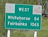
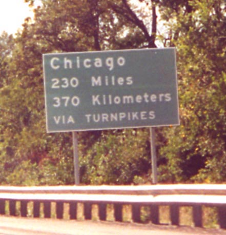
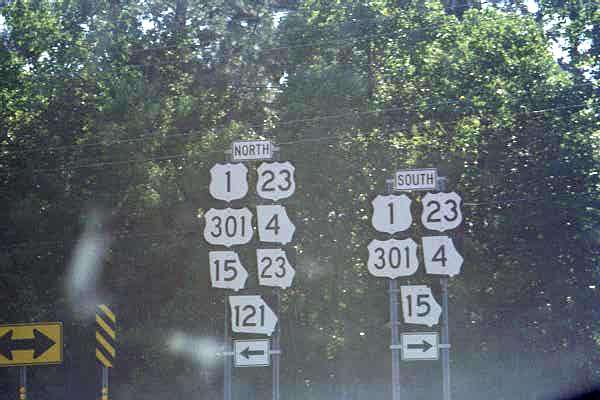