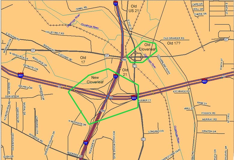
The Cloverleaf area
Map of the area

One of the oldest interchanges in Metro Cleveland
is at the south end of the Willow Freeway (most of which carries
I-77 but which is Ohio 21 at this point). This is a cloverleaf
interchange with Granger Road (Ohio 17). The interchange is
substandard for a modern freeway interchange: its ramps are actually
two-way roads, and they meet the highways which they access at
or close to right angles. The architecture of the overpass (viewed
from westbound Granger) is a giveaway that this interchange has
been here a while (note the I-77 overpass in the background as
a comparison). Because cloverleaf interchanges were novelties
when this one was built, the "cloverleaf" name was applied
quite a bit in the immediate area, eventually including...

The
term "the Cloverleaf" was reapplied to the nearby Interstate
77/Interstate 480 interchange when it was completed, even though
it's a "fully-directional"
or stack interchange! The ramps of this interchange overlap
with I-77's interchange with Rockside Road to the south (the green
overhead sign off to the far right is for a ramp to Rockside Road).
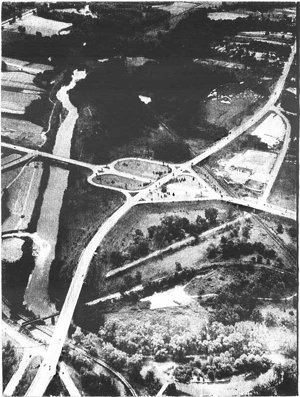
This is an aerial photograph (xeroxed) of the "cloverleaf" from 1946! The Willow Freeway comes from the bottom left and is heading south as it goes to the top of the picture. You can see the south end of E 71st (Old US 21) at the bottom left and another former section of US 21 on the far right side. I don't know how much of the railroad(s) in this picture are left today. The Cloverleaf opened October 21, 1940 (date courtesy of this Willow Freeway history article). From the Inventory of Needed Improvements on the State Highway System, Dec. 1946. Ohio Dept. of Highways
The Valley View Bridge
This tall bridge (212 feet high and 4150 feet long - source) carries I-480 across the Cuyahoga River, the Ohio Canal, and the adjacent valley just east of I-77. What's interesting is that even though I-77 crosses the river and the canal only a mile or so northwest of (downstream from) here, its bridges are much lower and less impressive because I-77 goes down into the valley somewhat.
(the three following pictures were taken in 1999)

Easternmost
section. Talk about commercialism! The bridge is high, but the
billboard poles are higher!

Middle
section. Note the "Cloverleaf" name. And more billboards!
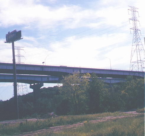
Westernmost
section
It is not known by the Roadfan.com maintainers
why the tall towers were built when smaller ones could have carried
the wires under the bridge.
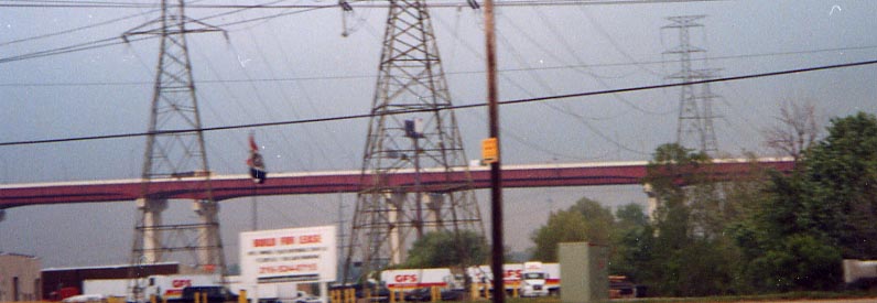
New
color, 2002

On
the Valley View Bridge westbound
Link to topo map of both of the interchanges and the bridge. Also see the Old US 21 page for more about this location.

I-77
Northbound at Harvard Avenue
I-77 between Ohio 21 north of the old Cloverleaf and Broadway/Ohio 14 is the Willow Freeway, one of Cleveland's oldest freeways (note the overpass), built as a relocated US 21. This part of I-77 is subject to flooding.
This section of I-77 is getting some overpasses rebuilt in 2004-2005 (Grant Avenue south of Harvard and Fleet Avenue to the north, and four railroad overpasses between Grant and Harvard). See these ODOT press releases: 2/26/04 | 4/21/04 | 6/17/04
Southeast Area
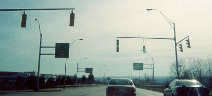
Rare
extant five-high left turn signal, I-480 at Transportation Boulevard/East
98th Street exit (note: the I-480 southern frontage road leading
east from this interchange, across from the I-480 Eastbound ramps,
Antenucci Boulevard, was named for Alfred Antenucci, the person
who subdued John Hinkley, Jr. after he fired at President Ronald
Reagan during the 1981 assassination attempt - WKYC-TV story
1 | story
2)
Many of the old five lens left turn signal have been replaced with what is called an "doghouse signal" throughout Ohio. Some vertical five lens lights remain on:
Transportation Boulevard gets its name from ODOT's District 12 headquarters, just behind and to the left.

Trucks need to avoid Oh 17 between I-480 (exit 22) and Broadway Ave (Oh 14). Not entirely sure as to the reason why.
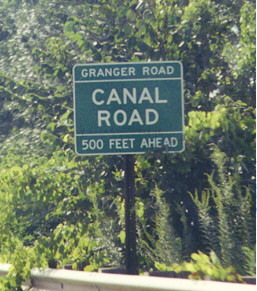
Cuyahoga
County advance street sign
These signs, and older black-on-white versions of them, like the neon turn restriction signs, are unique to Cuyahoga County and posted throughout the county. On westbound Granger, east of the old Cloverleaf and just north of the Valley View Bridge
Cloverleaf II
While
not as old as the 21-17 Cloverleaf to the west, this cloverleaf
between Warrensville Center Rd and Oh 43 (Miles Rd) is a relic
in comparison to modern interchanges.
Warrensville Center Rd going over Oh 43. Just over the southern horizon is a bridge over some Norfolk Southern tracks and then I-480.
NE Corner of Warrensville Center and Miles Rd. The ramps are divided by a double yellow line. No space for a divider...and shoulders
NW corner. Note the signage here. Keep right (for traffic going from SB Warrensville to WB Miles Rd, the no left sign on the far right of the photo, the Do Not Enter Sign, on the other side of Miles Rd, for anyone who might be tempted to tempt fate and use the opposite direction as a short cut.
OK, I admit, I'm just being silly here and leaving this misplaced shopping cart in color, while changing the rest of the photo to Black and White. To the left of the ridge is Randall Park Mall
The I-271/I-480 overlap -- lots of numerals

The
signs from left to right are for I-480 West, I-271 South/I-480
East (Express Lanes, which are officially called "IR 271X");
I-271 South/I-480 East, US 422 East, I-480 West, and Ohio 175/Emery
Road (Local Lanes). The westward extension of the US 422 freeway
before I-480 is unnumbered in the field and called I-480N in ODOT
records (see the ODOT
straight line diagram .pdf).
The I-271 Express Lanes were started in 1992, with the first major construction being the bridges over Harvard Road in the Summer of 1993 (I-271's interchange with Harvard, just behind in the photo above, would open July 21, 2000 -- article). The lanes were complete to within the Chagrin Blvd. (US 422/SR 87) interchange, merging temporarily into I-271 there, by November 30, 1995, and were finished to the I-480/US 422 interchange by November 25, 1998, after the ramp which carries US 422 EB was rebuilt (the ramp configuration within the interchange is the same as before, but the bridge supports had to be rebuilt in different places to accomodate the Express Lanes). There were also plans to extend the Express Lanes westward inside I-480 to I-77.
This page has some early history of I-271 as well as cancelled I-290.

Darker
shot
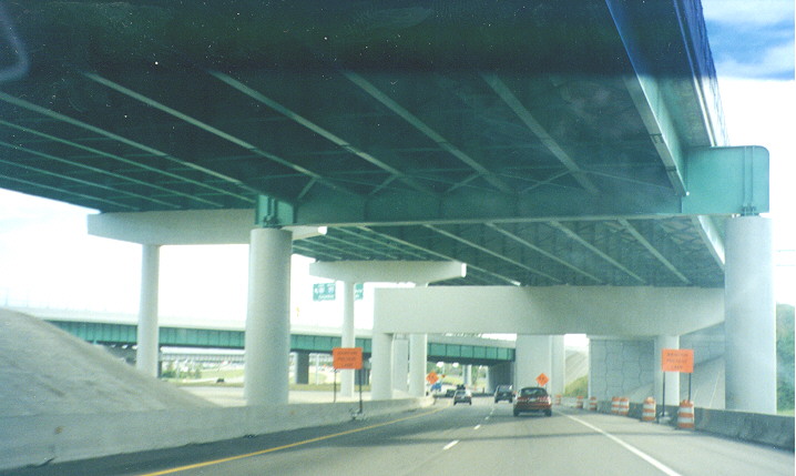
Southern
end of the I-271 Express Lanes
When the I-271 Express Lanes end at the US 422 East/I-480 West interchange, they only connect to the rest of I-271 with single slip ramps. The roadways continue over I-271 Southbound to connect directly with the I-480/US 422 connector (I-480N). The result is a pair of overpasses which resembles a tunnel.
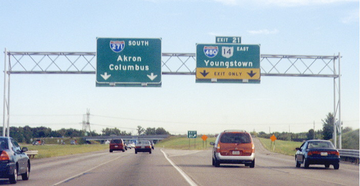
This
is the southern end of the only section of highway to carry multiple
three-digit Interstate routes.

This
is one of the two northbound assemblies (there are none southbound)
-- the other is on this
page (that one should also have an Ohio 14 marker, but that
is omitted presumably because at that point signage which shows
14 exiting onto Broadway has already appeared). Until the 1990s
only I-271 markers were posted along the concurrency.
Normally, there are no signage concerning the heights of bridges in Ohio once they pass 14 ft. However this underpass along Richmond Rd, between Solon and Bedford Hts. is the exception, since the margins are beneith the 14 ft. cutoff.

This photo along I-271 is in Medina Co. This is just northeast of I-271's southern terminus with I-71, looking northeast. For some reason, the median expands to triple the normal size. However there is nothing that shows any sort of road projects that would of used this space (unlike within Cuyahoga Co). The buildings beyond the overpass with Wilbur Road are part of what looks to be an asphalt processing plant used when I-271 was resurfaced through here in 1999.
Page created on December 25, 2002/Last updated on May 16, 2005
Questions and comments can be directed to Sandor Gulyas or Marc Fannin
Return to the Cleveland Virtual Roadtrip